weather – Page 4 – Michmutters
Categories
US

2 bodies found in burned vehicle in California wildfire zone

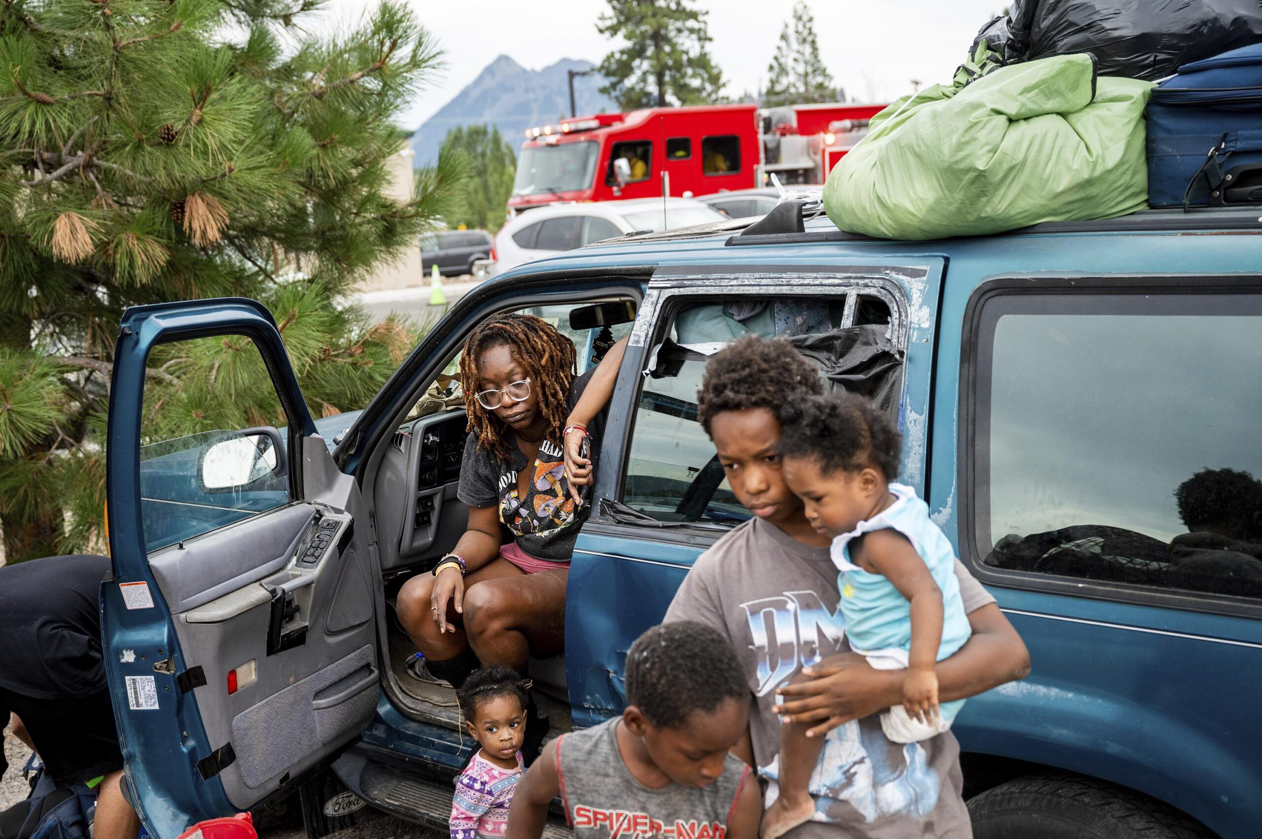
YREKA, Calif. (AP) — Two bodies were found inside a charred vehicle in a driveway in the wildfire zone of a raging California blaze that was among several threatening thousands of homes Monday in the western US, officials said. Hot and gusty weather and lightning storms threatened to increase the danger that the fires will keep growing,

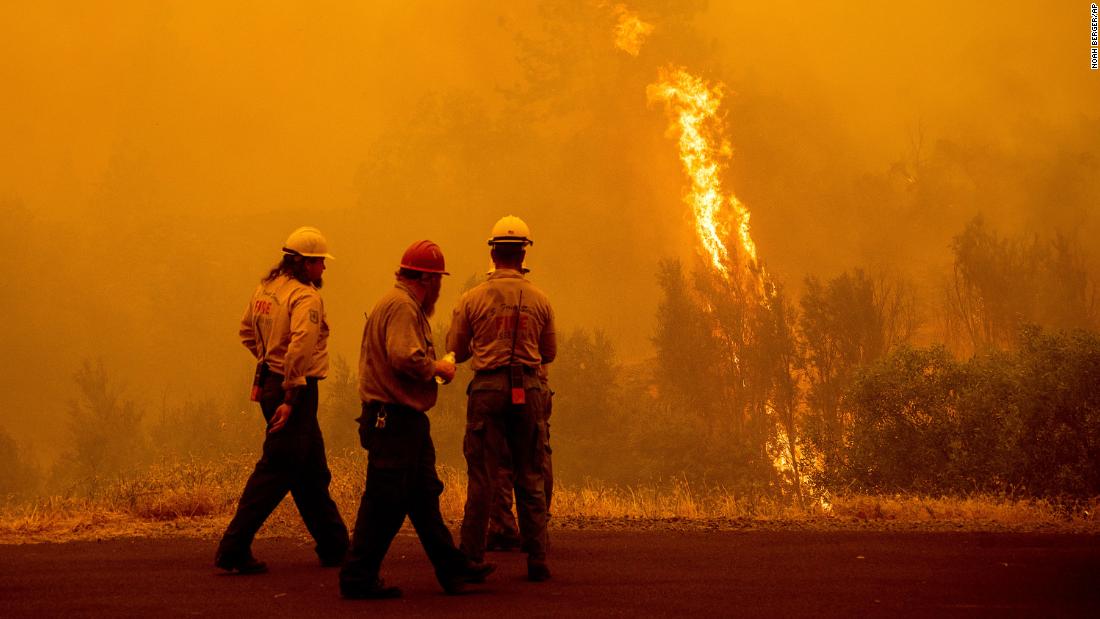
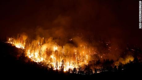
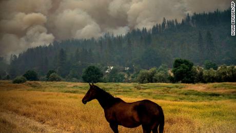
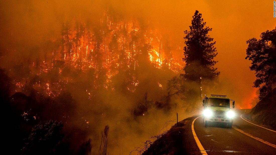
The McKinney Fire in Northern California near the state line with Oregon exploded in size to nearly 87 square miles (225 square km) after erupting Friday in the Klamath National Forest, firefighting officials said. It is California’s largest wildfire of the year so far and officials have not determined the cause.

The vehicle and the bodies were found Sunday morning in the driveway of a residence near the remote community of Klamath River, the Siskiyou County Sheriff’s Office said in a statement.

Nearly 5,000 Northern California homes and other structures were threatened and an unknown number of buildings have burned, said Adrienne Freeman, a spokesperson for the US Forest Service.

The smoky blaze cast an eerie, orange-brown hue in one neighborhood where a brick chimney stood surrounded by rubble and scorched vehicles on Sunday. Flames torched trees along State Route 96 and raced through hillsides in sight of homes.

Valerie Linfoot’s son, a fire dispatcher, called to tell her their family home of three decades in Klamath River had burned. Linfoot said her husband de ella worked as a US Forest Service firefighter for years and the family did everything they could to prepare their house for a wildfire — including installing a metal roof and trimming trees and tall grasses around the property.

“It was as safe as we could make it, and it was just so dry and so hot and the fire was going so fast,” Linfoot told the Bay Area News Group. She said her neighbors have also lost homes.

“It’s a beautiful place. And from what I’ve seen, it’s just decimated. It’s absolutely destroyed,” she told the news group.

Firefighting crews on the ground were trying to prevent the blaze from moving closer to the town of Yreka, population about 7,500. The blaze was about four miles (6.4 kilometers) away as of Monday.

rate
youtube video thumbnail

A second, smaller fire in the region that was sparked by dry lightning Saturday threatened the tiny California community of Seiad.

Freeman said “there has been significant damage and loss along the Highway 96 corridor” that runs parallel to the Klamath River and is one of the few roads in and out of the region.

She added: “But just how much damage is still being assessed.”

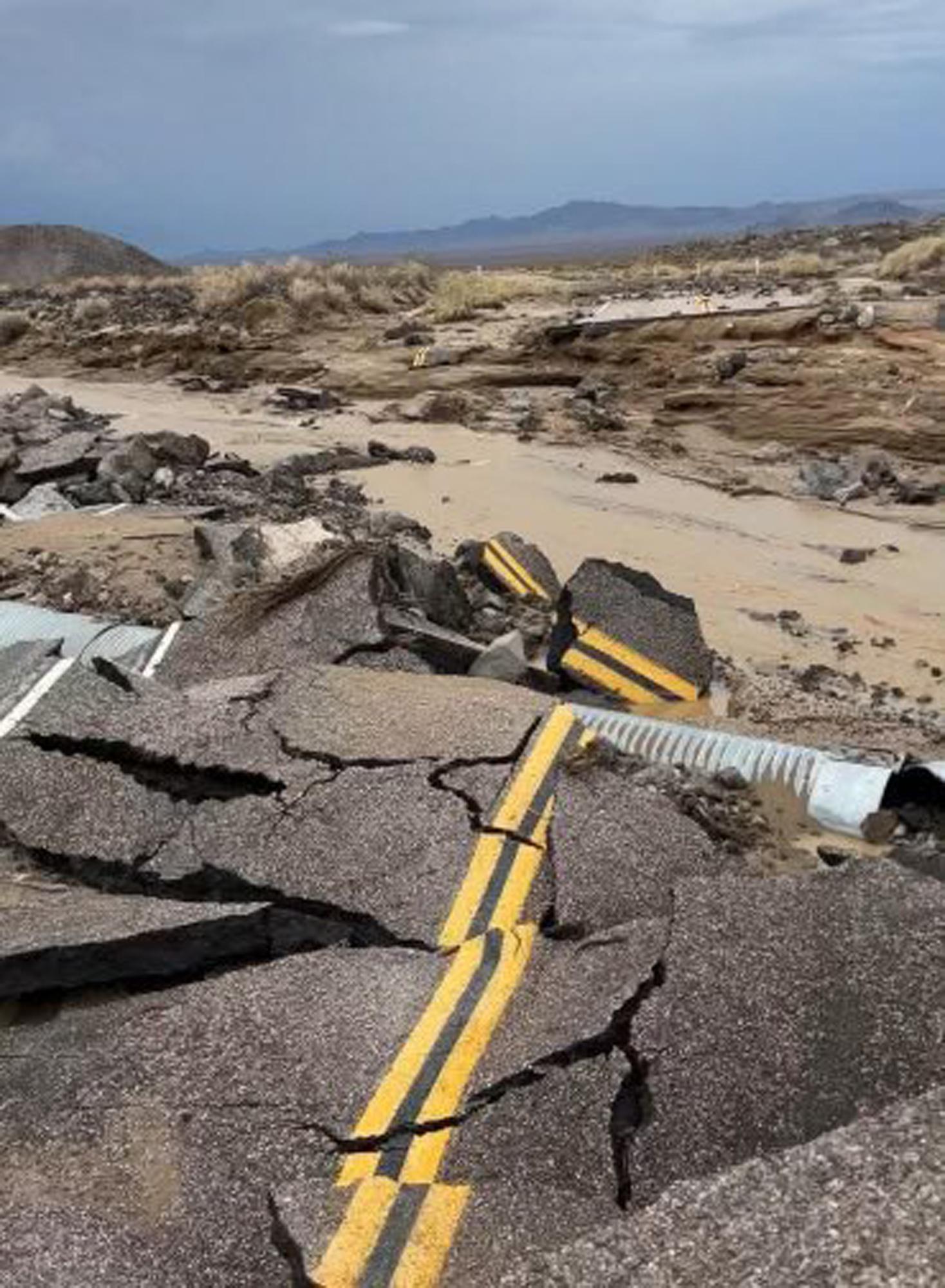
Erratic storms were expected to move through Northern California again on Monday with lightning that threatened to spark new fires in bone dry vegetation, forecasters said. A day earlier, thunderstorms caused flash flooding that damaged roads in Death Valley National Park and in mountains east of Los Angeles.

In northwestern Montana, a fire on the Flathead Indian Reservation that started in grasslands near the town of Elmo on Friday and moved into forested areas had grown to 20 square miles (52 square km) by Monday, fire officials said. Residents of about 20 homes were told to be prepared to evacuate.

The Moose Fire in Idaho has burned more than 85 square miles (220 square kilometers) in the Salmon-Challis National Forest while threatening homes, mining operations and fisheries near the town of Salmon. It was 23% contained Monday.

And a wildfire raging in northwestern Nebraska led to evacuations and destroyed or damaged several homes near the small city of Gering. The Carter Canyon Fire began Saturday as two separate fires that merged. It was about 30% contained by early Monday.

In California, Gov. Gavin Newsom declared a state of emergency Saturday, allowing him more flexibility to make emergency response and recovery effort decisions and to tap federal aid.

Scientists have said climate change has made the West warmer and drier over the last three decades and will continue to make weather more extreme and wildfires more frequent and destructive.

The US Forest service shut down a 110-mile (177 km) section of the famed Pacific Crest Trail in Northern California and southern Oregon and dozens of hikers in that area were urged to abandon their treks and head to the nearest towns.

___

Weber reported from Los Angeles. Associated Press reporters Amy Hanson in Helena, Montana; Margery Beck in Omaha, Nebraska; and Keith Ridler in Boise, Idaho contributed to this report.

.

Categories
US

Flash floods close roads into Death Valley National Park

In this photo released by the National Park Service, is the damaged intersection of Kelbacker Road and Mojave Road in the Mojave National Preserve, Calif., Sunday, July 31, 2022. Roads in and out of Death Valley National Park were closed after lanes mud and debris inundated lanes during weekend flash floods in eastern California, western Nevada and northern Arizona.  Storm cells dumped localized heavy rain across the region, prompting closures of highways and campgrounds.  (National Park Service via AP)

In this photo released by the National Park Service, is the damaged intersection of Kelbacker Road and Mojave Road in the Mojave National Preserve, Calif., Sunday, July 31, 2022. Roads in and out of Death Valley National Park were closed after lanes mud and debris inundated lanes during weekend flash floods in eastern California, western Nevada and northern Arizona. Storm cells dumped localized heavy rain across the region, prompting closures of highways and campgrounds. (National Park Service via AP)

In this photo released by the National Park Service, is the damaged intersection of Kelbacker Road and Mojave Road in the Mojave National Preserve, Calif., Sunday, July 31, 2022. Roads in and out of Death Valley National Park were closed after lanes mud and debris inundated lanes during weekend flash floods in eastern California, western Nevada and northern Arizona. Storm cells dumped localized heavy rain across the region, prompting closures of highways and campgrounds. (National Park Service via AP)

DEATH VALLEY NATIONAL PARK, Calif. (AP) — Some roads in and out of Death Valley National Park have been closed after they were inundated over the weekend with mud and debris from flash floods that also hit western Nevada and northern Arizona hard.

Officials on Sunday provided no estimate on when the roads around Death Valley would be reopened.

Motorists were also urged to avoid Southern California’s Mojave National Preserve after flooding buckled pavement on some roads. The rain also prompted closures of highways and campgrounds elsewhere, but no injuries were reported

The storms produced torrential downpours and the National Weather Service reported that more than an inch (2.5 centimeters) of rain fell in 15 minutes Sunday near Kingman, Arizona, which is close to the stateline with California.

In a mountainous area east of Los Angeles at the edge of the San Bernardino National Forest, mudslides sent trees and large rocks onto roads, blocking them near the city of Yucaipa.

Forecasters said more thunderstorms were possible on Monday.

.

Categories
US

Infrastructure damage hampers flood recovery in Kentucky

HINDMAN, Ky. (AP) — Damage to critical infrastructure and the arrival of more heavy rains hampered efforts Sunday to help Kentucky residents hit by recent massive flooding, Gov. Andy Beshear said.

As residents in Appalachia tried to slowly piece their lives back together, flash flood warnings were issued for at least eight eastern Kentucky counties. The National Weather Service said radar indicated up to 4 inches (10.2 centimeters) of rain fell Sunday in some areas, with more rain possible.

Beshear said the death toll climbed to 28 on Sunday from last week’s storms, a number he expected to rise significantly and that it could take weeks to find all the victims.

Thirty-seven people were unaccounted for as search and rescue operations continued early Sunday, according to a daily briefing from the Federal Emergency Management Agency. A dozen shelters were opened for flood victims in Kentucky with 388 occupants.

Gen. Daniel Hokanson, chief of the US National Guard Bureau, told The Associated Press about 400 people have been rescued by National Guard helicopter. I have estimated that the guard had rescued close to 20 by boat from hard-to-access areas.

At a news conference in Knott County, Beshear praised the fast arrival of FEMA trailers but noted the numerous challenges.

“We have dozens of bridges that are out — making it hard to get to people, making it hard to supply people with water,” he said. “We have entire water systems down that we are working hard to get up.”

Beshear said it will remain difficult, even a week from now, to “have a solid number on those accounted for. It’s communications issues — it’s also not necessarily, in some of these areas, having a firm number of how many people were living there in the first place.”

The governor also talked about the selflessness he’s seen among Kentucky residents suffering from the floods.

“Many people who have lost everything but they’re not even getting goods for themselves, they’re getting them for other people in their neighborhoods, making sure that their neighbors are OK,” Beshear said.

Among the stories of survival that continue to emerge, a 17-year-old girl whose home in Whitesburg was flooded Thursday put her dog in a plastic container and swam 70 yards to safety on a neighbor’s roof. Chloe Adams waited hours until daylight before a relative in a kayak arrived and moved them to safety, first taking her dog from her, Sandy, and then the teenager.

rate
youtube video thumbnail

“My daughter is safe and whole tonight,” her father, Terry Adams, said in a Facebook post. “We lost everything today… everything except what matters most.”

On an overcast morning in downtown Hindman, about 200 miles (322 kilometers) southeast of Louisville, a crew cleared debris piled along storefronts. Nearby, a vehicle was perched upside down in Troublesome Creek, now back within its debris-littered banks.

Workers cleaned nonstop through mud-caked sidewalks and roads.

“We’re going to be here unless there’s a deluge,” said Tom Jackson, who is among the workers.

Jackson was with a crew from Corbin, Kentucky, where he’s the city’s recycling director, about a two-hour drive from Hindman.

His crew worked all day Saturday, and the mud and debris were so thick that they managed to clear one-eighth of a mile of roadway. The water rushing off the hillsides had so much force that it bent road signs.

“I’ve never seen water like this,” Jackson said.

Attendance was down for the Sunday morning service at Hindman’s First Baptist Church. Parishioners who rarely miss a service were instead back home tending to cleanup duties caused by floodwaters and mud.

The Rev. Mike Caudill said his church has pitched in to help the reeling community, serving meals and setting up tents for people to pick up cleaning and personal hygiene supplies.

Totes filled with clothes and photos were stacked on retired teacher Teresa Perry Reynolds’ front porch, along with furniture too badly damaged to salvage.

“There are memories there,” she said of the family photos she and her husband were able to gather.

Her husband’s wallet, lost as they escaped the fast-rising water Thursday to go to a neighbor’s house, was later found.

“All I know is I’m homeless and I’ve got people taking care of me,” she said.

Parts of eastern Kentucky received between 8 and 10 1/2 inches (20-27 centimeters) over 48 hours. About 13,000 utility customers in Kentucky remained without power Sunday, poweroutage.us reported.

President Joe Biden declared a federal disaster to direct relief money to more than a dozen Kentucky counties.

Last week’s flooding extended to West Virginia, where Gov. Jim Justice declared a state of emergency for six southern counties, and to Virginia, where Gov. Glenn Youngkin also made an emergency declaration that enabled officials to mobilize resources across the flooded southwest portion of the state.

___

Raby reported from Charleston, West Virginia. Associated Press writer Kevin McGill in New Orleans contributed to this report.

.

Categories
Australia

Perth and WA weather: Bureau of Meteorology issues warning as second front set to bring monster swell

West Aussies are being told to brace for a second cold front with swell heights forecast to hit a two-year record and up to 51mm of rain falling in the wettest part of the State.

The Bureau of Meteorology has issued a severe weather warning for the southern part of WA, including the regions surrounding Perth, Mandurah the South West, Katanning, Manjimup, Merredin, Mount Barker and Northam.

Heavy rains and damaging wind likes are being forecast — and it isn’t expected to subside for at least another two days.

Your local paper, whenever you want it.

“A second front will move across the coast later this week, prolonging the severe weather conditions in WA through to Wednesday,” the Bureau said.

Pictures of wet weather in Perth.  Pictures on St Georges Terrace in Perth.
Camera IconPerth has been smashed by heavy rains and wild winds. Credit: ross swanborough/The West Australian

By 5pm Monday, State Emergency Services volunteers had been bombarded with calls from distressed residents struggling with leaking roofs and flooding.

Walpole, in the State’s South West, was the wettest region of WA with a whopping 51mm of rain in the gauge over the past two days.

In Perth, the hills suburb of Bickley received the most rain on Monday, recording 30.6mm by 6pm.

Pictures of wet weather in Perth.  Pictures on Riverside Drive in Perth.
Camera IconRoads were waterlogged in the Perth CBD on Monday. Credit: ross swanborough/The West Australian

The coast also got a battering, with 22.2mm falling in the Swanbourne rain gauge and 89km/h wind gusts recorded at 4.12pm.

Wind gusts have been relentless across WA with 90km to 100km winds recorded at Cape Naturaliste, while Geraldton Airport recorded 87km/h winds.

And while surfers are being told to stay away from the water during the weather warning, the swell is rapidly rising.

Wet weather hits the Perth metro area on 1 Aug, 2022.
Camera IconHuge swell is being forecast for the Perth coast this week. Credit: matt jelonek/The West Australian

On Rottnest Island, an enormous swell height of 9.5m is being forecast — the biggest in more than two years — and monster wave heights are expected in other areas too.

“Significant wave heights exceeding 7 meters are expected in exposed locations. Waves will arrive from West to South Westerly directions,” the Bureau said.

The wild weather has prompted the RSPCA to issue a warning to pet owners to comfort their animals.

Pictures of wet weather in Perth.  Pictures on St Georges Terrace in Perth.
Camera IconCommuters were hit by wet conditions on Monday. Credit: ross swanborough/The West Australian

“The winter months can put pets at risk, but luckily there are simple steps we can take to prepare, and make sure our animals stay warm and protected from the wind, rain and cold,” she said.

“Cold and wet weather conditions bring a new influence of cruelty reports to our Inspectorate.

“Last winter, RSPCA WA received over 1500 reports, with common issues being insufficient food, water and shelter, abandonment, and animals in need of vet treatment.

“Protecting your pet this winter could be as simple as providing some extra bedding, food, and somewhere warm and dry for them to escape.”

PERTH WEATHER FORECAST

  • monday – 20C – Showers, possible afternoon storm, 15-20mm
  • tuesday – 10-16C – Showers. Becoming windy, 10-15mm
  • wednesday – 9-16C – Rain, becoming windy, 15-25mm
  • thursday – 10-17C – Showers easing, 3-6mm
  • friday – 7-16C – Shower or two, 0-1mm

.

Categories
US

Parkland trial a rare, curtailed look at mass shooting gore

Broward Sheriff’s Office Sgt. Richard Van Der Eems describes the scene he encountered at the school after the mass shooting as he testifies during the penalty phase trial of Marjory Stoneman Douglas High School shooter Nikolas Cruz, Friday, July 22, at the Broward County Courthouse in Fort Lauderdale, Fla. (Mike Stocker, South Florida Sun-Sentinel via AP)

Estimated read time: 5-6 minutes

FORT LAUDERDALE, Fla. — Few Americans outside law enforcement and government ever see the most graphic videos or photos from the nation’s worst mass shootings — in most states, such evidence is only displayed at trial and most such killers die during or immediately after their attacks . They never make it to court.

That has made the penalty trial of Florida school shooter Nikolas Cruz for his 2018 murder of 17 people at Parkland’s Marjory Stoneman Douglas High School unusual.

As the worst US mass shooting to reach trial, the surveillance videos taken during his attack and the crime scene and autopsy photos that show its horrific aftermath are being seen by jurors on shielded video screens and, after each day’s court session, shown to a small group of journalists. But they are not shown in the gallery, where parents and spouses sit, or to the general public watching on TV.

Some online believe that should change — that to have an informed debate on gun violence, the public should see the carnage mass shooters like Cruz cause, often with high-velocity bullets fired from AR-15 semiautomatic rifles and similar weapons.

Others disagree. They say the public display of such videos and photos would add to the harm the victims’ families already endure and might entice some who are mentally disturbed to commit their own mass shooting. They believe such evidence should remain sealed.

Liz Dunning, a vice president at the Brady Center to Prevent Gun Violence, doesn’t believe releasing such videos and photos would have the political impact some think. Polls show that most Americans already support stronger background checks for gun buyers and bans or restrictions on AR-15s and similar weapons, said Dunning, whose mother was murdered by a gunman.

“Public perception is not the issue,” Dunning said. “We should be asking more of the powerful.”

Since most of the worst US mass shooters were killed by themselves or police during or immediately after their attack, it is rare for anyone outside government to see such surveillance videos or police and autopsy photos. The public didn’t see such evidence after the Las Vegas shooting in 2017, Orlando in 2016, Sandy Hook in 2012, Virginia Tech in 2007 and others.

Medical Examiner Dr. Wendolyn Sneed describes the wounds of Marjory Stoneman Douglas High School victims as she testifies in the penalty phase of Marjory Stoneman Douglas High School shooter Nikolas Cruz's trial at the Broward County Courthouse in Fort Lauderdale, Fla., on Monday, July 25 .
Medical Examiner Dr. Wendolyn Sneed describes the wounds of Marjory Stoneman Douglas High School victims as she testifies in the penalty phase of Marjory Stoneman Douglas High School shooter Nikolas Cruz’s trial at the Broward County Courthouse in Fort Lauderdale, Fla., on Monday, July 25 (Photo: Carline Jean, South Florida Sun-Sentinel via AP)

But Cruz, 23, fled after his shooting and was arrested an hour later. He pleaded guilty in October to 17 counts of his first-degree murder-his trial is only to determine if he is sentenced to death or life without parole. The videos and photos are part of the prosecution’s case.

Since the trial began July 18, everyone in the courtroom and watching on TV has seen and heard heartbreaking testimony from teachers and students who saw others die. They have heard the gunshots and screams as jurors watched cellphone videos.

But when graphic videos and photos are presented, those are not shown. Usually, they only hear medical examiners and police officers give emotionless descriptions of what the jury is seeing.

Then at the end of each day, a group of reporters reviews the photos and videos, but are only allowed to write descriptions. That was a compromise as some parents feared photos of their dead children would be posted online and wanted no media access.

Miami media attorney Thomas Julin said in Florida before the internet, any photos or other evidence presented at trial could be seen and copied by anyone. Newspapers didn’t print the most thick photos, so no one cared.

But in the mid-1990s as the internet boomed, Danny Rolling faced a death penalty trial for the serial murders of four University of Florida students and a community college student. The victims’ families argued that the publication of crime scene photos would cause them emotional harm. The judge ruled that anyone could view the photos, but no one could copy them. Such compromises have since become standard in Florida’s high-profile murder trials.

The surveillance video of the Stoneman Douglas shooting is silent. It shows Cruz moving methodically from floor-to-floor in a three-story classroom building, shooting down hallways and into classrooms. Victims fall. Cruz often stops and shoots them again before moving on.

The crime scene photos show the dead where they fell, sometimes on top of or next to each other, often in contorted shapes. Blood and sometimes brain matter are splattered on floors and walls.

Marjory Stoneman Douglas High School shooter Nikolas Cruz is led into the courtroom during the penalty phase of his trial at the Broward County Courthouse in Fort Lauderdale, Fla., on Monday, July 25.
Marjory Stoneman Douglas High School shooter Nikolas Cruz is led into the courtroom during the penalty phase of his trial at the Broward County Courthouse in Fort Lauderdale, Fla., on Monday, July 25. (Photo: Carline Jean, South Florida Sun-Sentinel via P.A.)

The autopsy photos show the damage Cruz and his bullets did. Some victims have massive head wounds. One student had his elbow blown off, another had her shoulder blown open. Another of her had most of her forearm of her ripped away.

Yet, despite their grossness, Columbia University journalism professor Bruce Shapiro says most autopsy and crime scene photos wouldn’t have a lasting public impact because they don’t have context.

The photos and videos that have a strong effect on public opinion tell a story, said Shapiro, who runs the university’s think tank on how journalists should cover violence.

The photos of Emmett Till’s battered body lying in its coffin after the Black teenager was tortured and killed by Mississippi white supremacists in 1955. Mary Ann Vecchio screaming over Kent State student Jeffrey Miller’s body after he was shot by National Guard troops in 1970. Vietnamese child Phan Thi Kim Phuc running naked after being burned by a napalm bomb in 1972. The video of police officer Derek Chauvin kneeling on George Floyd’s neck until he’s dead in 2020.

“They work not just because they are graphic, but because they are powerful, stirring images,” Shapiro said.

And even if the graphic photos and videos were released, most major newspapers, wire services and television stations would be hesitant to use them. Their editors weigh whether the public benefit of seeing an image outweighs any prurient interest — and they usually pass.

That would leave most for only the most salacious websites. They would also become fodder for potential mass shooters, who frequently research past killers. cross did; testimony showed he spent the seven months before his attack making hundreds of computer searches about committing massacres.

“The images of the carnage will become part of their dark fantasy life,” Shapiro said.

Photos

related stories

Most recent US stories

More stories you may be interested in

.

Categories
US

McKinney Fire: In just 3 days, the Northern California fire has exploded to become the state’s largest blaze this year

The blaze, dubbed the McKinney Fire, broke out Friday afternoon in the Klamath National Forest near the California-Oregon border and has since ripped through more than 52,000 acres, advancing on homes and forcing nearly 2,000 residents to evacuate Saturday, authorities said.

Heavy smoke over the fire helped slow its growth Sunday, but also kept firefighting aircraft grounded, the US Forest Service said in a Sunday night update.

As the weekend ended, the blaze was 0% contained and firefighters face a long battle ahead as lightning and thunderstorms complicated efforts while the flames raced through dry vegetation.

Oregon state Rep. Dacia Grayber was camping with her husband, both firefighters, near the California state line when they woke up to orange skies, hot wind gusts, lightning and blowing ash, she said on Twitter. They evacuated from the campground knowing one of them may return on deployment if the fire grows.
“In 22+ yrs of fire I’ve never experienced anything like this fire behavior at night. It felt absolutely surreal and not just a little apocalyptic,” grayber tweeted.
The area remained under a Red Flag Warning as a threat of dry lightning, strong winds, high temperatures and low humidity created dangerous fire conditions through Sunday night. “Abundant lightning” is expected through Monday, as well as scattered thunderstorms that could potentially spread the flames out further, according to the National Weather Service.
“These conditions can be extremely dangerous for firefighters, as winds can be erratic and extremely strong, causing fire to spread in any direction,” forest service officials said in a news release.

The dry thunderstorms that occurred over the weekend happen when rainfall evaporates before ever hitting the ground, leaving only lightning strikes capable of sparking new fires and fueling existing ones, CNN Meteorologist Robert Shackelford said.

The McKinney Fire burns near Yreka, California, Saturday.

At an estimated 52,498 acres, the McKinney Fire has become California’s largest wildfire so far this year, Cal Fire Capt. Chris Bruno told CNN.

And it isn’t the only blaze crews have to contend with. There were 10 different wildfires burning in the Klamath National Forest Sunday afternoon, forest officials said.

The fires generated their own weather in the form of pyrocumulus clouds, which are created from the intense heat of the fire forcing air to rise.
Tor Mason was one of the hundreds evacuated due to the McKinney Fire. He said he and his friends fled their homes and arrived at the Klamath River Community Center, only to find the fire closing in, he told CNN affiliate KDRV.

“When I got to the community center it was almost on fire. I’m like, holy crap, this isn’t good,” Mason said. “So I put the … pedal to the metal and I boogied. … I heard this morning it shot up in flames.”

California’s persistent drought conditions have set the scene for rapid fire spread in the forest, with the fires burning extremely dry, receptive fuels, according to the forest service.

Racing through dry brush, grass and timber, the fire activity has been extreme, with the flames running uphill, and spotting further out, according to fire officials.

“Klamath National Forest is a big and beautiful forest, but it also has some steep and rugged terrain. And with that, coupled with the high temperatures, low humidity, they all come into play and make it a very extreme fire danger situation right now ,” Tom Stokesberry of the US Forest Service told CNN affiliate KTVL.
A horse grazes in a pasture as the McKinney Fire burns in Klamath National Forest, in California Saturday.

A total of 648 firefighting personnel have converged on the blaze, attacking the flames from the ground and the air and working to defend evacuated homes.

Gov. Gavin Newsom proclaimed a state of emergency Saturday for Siskiyou County, saying the blaze has destroyed homes and threatened critical infrastructure. Cal Fire said no information was available on structures damaged by the McKinney Fire, though Stokesberry told KTVL there were unconfirmed reports of lost structures.
On Saturday, about 60 people were evacuated from the Pacific Crest Trail as the McKinney Fire approached, the Jackson County Sheriff’s Office in Oregon said on its Facebook page, noting the hikers were rescued from the “California side of the Red Buttes Wilderness.”
Conditions could get better Monday as the chance of isolated dry thunderstorms shifts to the north, Shackelford said. There is also a chance for up to 2 inches of rain falling over the area, which could aid firefighters battling the McKinney Fire.

CNN’s Paradise Afshar, Tina Burnside, Amanda Jackson, Robert Shackelford and Claire Colbert contributed to this report.

.

Categories
Australia

Peak-hour chaos as crash, breakdowns on Kwinana Freeway and Tonkin Highway add to heavy rain delays

Peak-hour traffic has been hit across the metropolitan area by several incidents as heavy rain causes widespread delays.

Motorists northbound on Kwinana Freeway need to be extra careful on the approach to South Terrace in Como with the left lane blocked after an accident.

Your local paper, whenever you want it.

Main Roads have warned of slow traffic in the area.

There have also been a number of breakdowns across the metropolitan area, with the right lane blocked on Tonkin Highway northbound after Roe Highway in Kewdale.

Traffic is slow on approach, with visibility in the wet also hampered.

Traffic is also slow on Tonkin Highway southbound prior to Morley Drive in Morley after a breakdown.

Tow trucks are dealing with the issue in the left emergency lane.

There has been a truck breakdown on the Kwinana Freeway in South Perth.

Emergency services have closed the left lane prior to Mill Point Road.

And Main Roads have warned holidaymakers heading to Perth Airport to allow extra travel time with roadworks closing Tonkin Highway from Great Eastern Highway to Dunreath Drive for bridge removal and construction.

The works started at 4am on Monday, with motorists told to seek alternative routes.

Thick smoke is also making driving difficult on Mitchell Freeway between Neerabup Road and Hester Avenue.

With reduced visibility in the area, motorists have been told to switch on their headlights and take extreme caution.

The latest incidents come after a crash on Kwinana Freeway in Baldivis prior to Karnup Road caused delays on Sunday night.

With wet weather to continue throughout Monday and into Tuesday, motorists across Perth have been warned to stay vigilant, switch on headlights and ensure a safe braking distance to the vehicle in front.

.

Categories
US

Kentucky flooding: More rain to strike already drenched and devastated communities as region remains in search and rescue mode after fatal flooding

“The forecast is concerning, and we’re watching it very closely, obviously. We also are sending out warnings and making sure everyone knows,” said Col. Jeremy Slinker, the Kentucky emergency management director.

“We’re preparing for it and making sure all the residents there are prepared for it because we just don’t want to lose anyone else or have any more tragedy,” he told CNN’s Pamela Brown Saturday.

A flood watch is in effect through at least Monday morning for parts of southern and eastern Kentucky, according to the National Weather Service, and there is a Level 3 of 4 moderate risk for excessive rainfall Sunday across southeastern Kentucky, per the Weather Prediction Center, escalating the concern of additional flooding.

Widespread rainfall totals of 1 to 3 inches are forecast over the next 24 to 48 hours, but as much as 4 or 5 inches is possible in localized areas. As little as 1 to 2 inches can revive flooding concerns, particularly in areas already inundated with heavy rain where the soil is saturated.

The ominous forecast comes as crews in eastern Kentucky continue their search for people who remained unaccounted for after the devastating flooding last Thursday inundated homes and swept some from their foundations, sending residents fleeing for higher ground.

Twenty-six people have been confirmed dead, Gov. Andy Beshear said on NBC’s “Meet The Press” Sunday, in what officials described as unprecedented flooding for the region. The death toll is expected to climb as crews gain more access to currently impassable areas, Beshear told CNN Saturday.

“There are still so many people unaccounted for,” Beshear said. “It’s going to get worse.”

A 17-year-old swam out of her flooded home with her dog and waited for hours on a roof to be rescued

Officials believe thousands have been affected, and efforts to rebuild some areas may take years, the governor has said. The state’s estimated losses are potentially in the “tens if not the hundreds of millions of dollars,” Beshear noted Saturday.

After the rain, excessive heat is expected to build over the region Tuesday as many people are currently struggling with no access to clean drinking water, power outages and cell service still out in some counties Saturday.

More than 10,000 homes and businesses in the region were in the dark early Sunday, according to PowerOutage.us; three drinking water systems were totally out of operation Saturday, the governor said.

“The water is still high in some counties. It’s crested in most, but not all. Water systems overwhelmed. So, either no water or water that’s not safe, that you have to boil,” Beshear said.

The federal government sent tractor trailers of bottled water to the region, and more financial assistance is on the way.

The flooding — as with other recent weather disasters — was further amplified by the climate crisis: As global temperatures climb as a result of human-caused fossil fuel emissions, the atmosphere is able to hold more water, making water vapor more abundantly available to fall as rain.
Scientists are increasingly confident in the role the climate crisis plays in extreme weather, and have warned such events will become more and more intense dangerous with every fraction of a degree of warming.

‘Hero’ rescued family from flooded home

Among the tales of heroism emerging from the disaster is an unidentified man who drifted through fast-moving water to get a 98-year-old grandmother, her grandson and another family member out of their home as it was nearly swallowed by the flooding Thursday.

Randy Polly, who witnessed the rescue in Whitesburg, Kentucky, and recorded parts of it on his cellphone, told CNN he got stuck a distance away from home on his way to get gas Thursday morning.

Polly said he heard people yelling across the flooded road, “Get me help, get help.” He called 911, but first responders were overwhelmed and unresponsive to his calls from him.

Gregrory Amburgey with his 98-year-old grandmother Mae Amburgey inside a home submerged in water.

Around 9 am, he saw a man he described as a hero drift over to the house and start banging on the door and window.

The man eventually helped get three people out of the home and guided them through rushing water, the videos show. The rescue took about 30 minutes, Polly said.

Missy Crovetti, who lives in Green Oaks, Illinois, told CNN the people rescued in the video are her grandmother Mae Amburgey, uncle Larry Amburgey and brother Gregory Amburgey. They are safe and doing well, she said.

Crovetti said she does not know the name of the man who rescued her family. Polly also said he does not know the man’s name.

Financial help in progress

Officials have moved swiftly to approve financial assistance, given the scores of people in need of relief after losing everything.

The federal government greenlighted funding for people in five counties “at a pace that we’ve never seen before,” Kentucky Lt. Gov. Jacqueline Coleman told CNN’s Pamela Brown Saturday.

Tips for staying safe in flooding: Keep an ax in the attic

“Residents will actually receive direct payments, which is some really good news in what will be a very long tunnel to see the light,” Coleman said.

Coleman did not provide an exact date on when those payments are expected to reach residents, though she said they will be dispersed as soon as the state receives the money.

Additionally, nearly $700,000 has been raised for relief efforts, Beshear said Saturday. He noted funeral expenses for those killed in the flooding will be paid for.

Libby Duty, 64, of Jenkins, Kentucky walked through her back yard while clearing out her basement on Saturday after historic rains flooded many areas of eastern Kentucky.

“We value ensuring that these loved ones can be reconnected with their family members, and to make sure that these folks are able to have a proper funeral for their loved ones,” Coleman said.

Additionally, the state is prioritizing placing generators at the shelters for flood survivors as temperatures are expected to soar Tuesday following the rain.

CNN’s Sharif Paget, Gene Norman, Derek Van Dam, Haley Brink, Jalen Beckford, Angela Fritz and Raja Razek contributed to this report.

.

Categories
Australia

Perth weather: Perth is set to cop up to 75mm of rain and damaging winds over the next three days

Batten down the hatches.

Perth is set to cop up to 75mm of rain and damaging winds over the next three days.

The bureau is forecasting a very high chance of showers on Monday with the chance of a thunderstorm.

Damaging winds are also possible, the bureau has warned, with up to 25mm of rain predicted.

.

Categories
US

Northern California wildfire exacerbated by weather, causing significant growth

The fire has already burned 30,000-40,000 acres with potentially dangerous storms possible Saturday, according to an update from Klamath National Forest.

“Cumulus clouds are developing in the fire area, which have potential to exacerbate fire behavior,” Klamath National Forest said in a Facebook post Saturday afternoon.
Gov. Gavin Newsom proclaimed a state of emergency Saturday for Siskiyou County, saying the blaze has threatened critical infrastructure and forced nearly 2,000 residents to flee their homes.

The fire, known as the McKinney fire, started on Friday in Siskiyou County near the California-Oregon border, about four hours north of Sacramento. The county has a population of just about 44,000, according to the US Census Bureau.

A mandatory evacuation order was announced for parts of Siskiyou County on Saturday, according to the Siskiyou County Sheriff’s Office. Residents within the evacuation zone are being asked to “please leave immediately.”

A red flag warning, which indicates dangerous fire conditions, is in effect. Lightning is expected in the area, and fire managers were “expecting a very dynamic day [Saturday] on the fire as predicted weather is expected to be problematic for the firefighters,” according to InciWeb’s update.

Firefighters were forced to shift their tactics “from an offensive perimeter control effort” to more of a defensive posture to assist with evacuations Saturday morning, the InciWeb report notes. Estimates on the McKinney Fire’s containment have not yet been made available Saturday afternoon.

Two other fires burning in Siskiyou County — the China 2 and Evans fires — merged and together burned more than 300 acres, prompting evacuation warnings for more than 200 residents, according to the governor’s office.

The state of emergency is meant to unlock state resources and allow firefighters from other states to help crews battling the fires in California, according to the governor’s office.

.