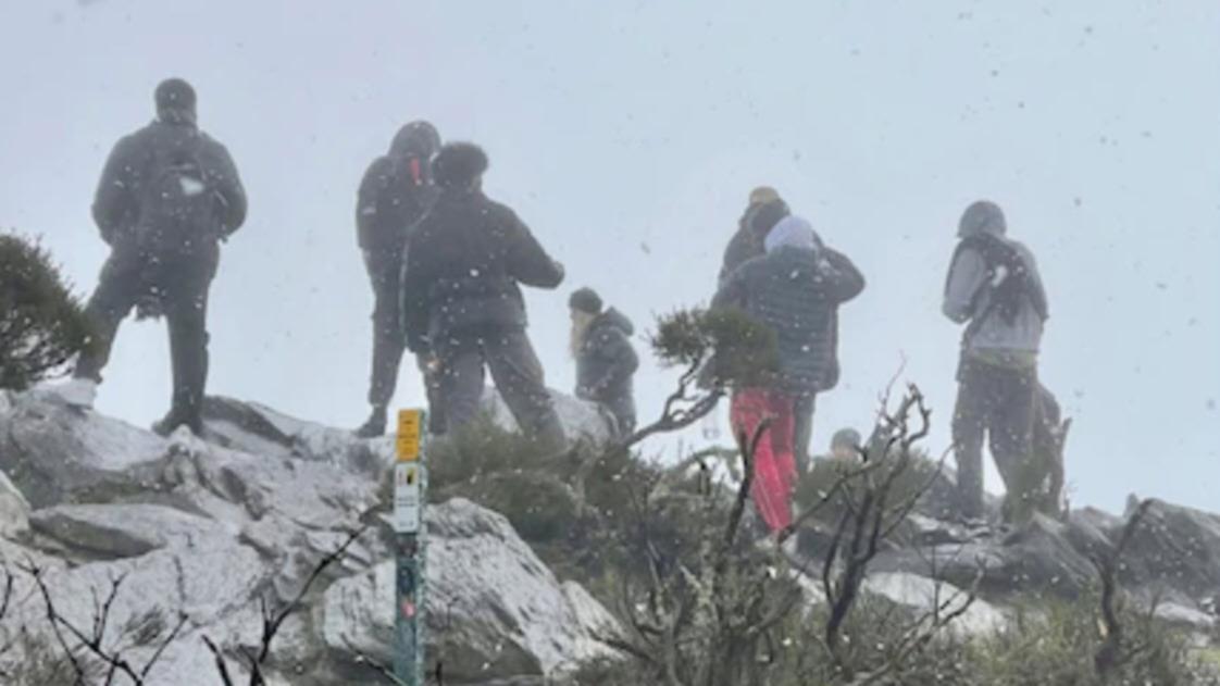
Stunning photos of snow falling near Bluff Knoll have emerged after the Stirling Range was treated to a light dusting on Tuesday.
Several hikers braved freezing cold conditions to see the snow up close as it fell near one of WA’s highest peaks.
Photos posted to social media show hikers giving the thumbs up to their mates as a steady stream of snow falls around them.
Other photos show large amounts of snow covering the ground and earth of Bluff Knoll, as a thick fog lingers nearby.
Snow falls in Stirling Range National Park and Bluff Knoll as a cold snap hits Western Australia. Credit: Frederick Schafsma/Frederick Schafsma
The Bureau of Meteorology had predicted snow would fall in the Great Southern after a cold front moved across Perth and South West on Monday and Tuesday morning.
Cool air behind the cold front meant the upper-level air temperatures were also very low, which created almost ideal conditions for a light amount of snowfall to reach the Bluff Knoll peak.
Snow was recorded at least five times last year in the Stirling Range, equaling a record set 53 years ago.
The State’s record top of six snow flurries in one 12-month period came in 2016, with all recorded at Bluff Knoll.
The Bureau of Meteorology relies on hikers to confirm snowfall at Bluff Knoll, which is the highest peak in southern WA at 1,099 meters, because there’s no observation equipment there.
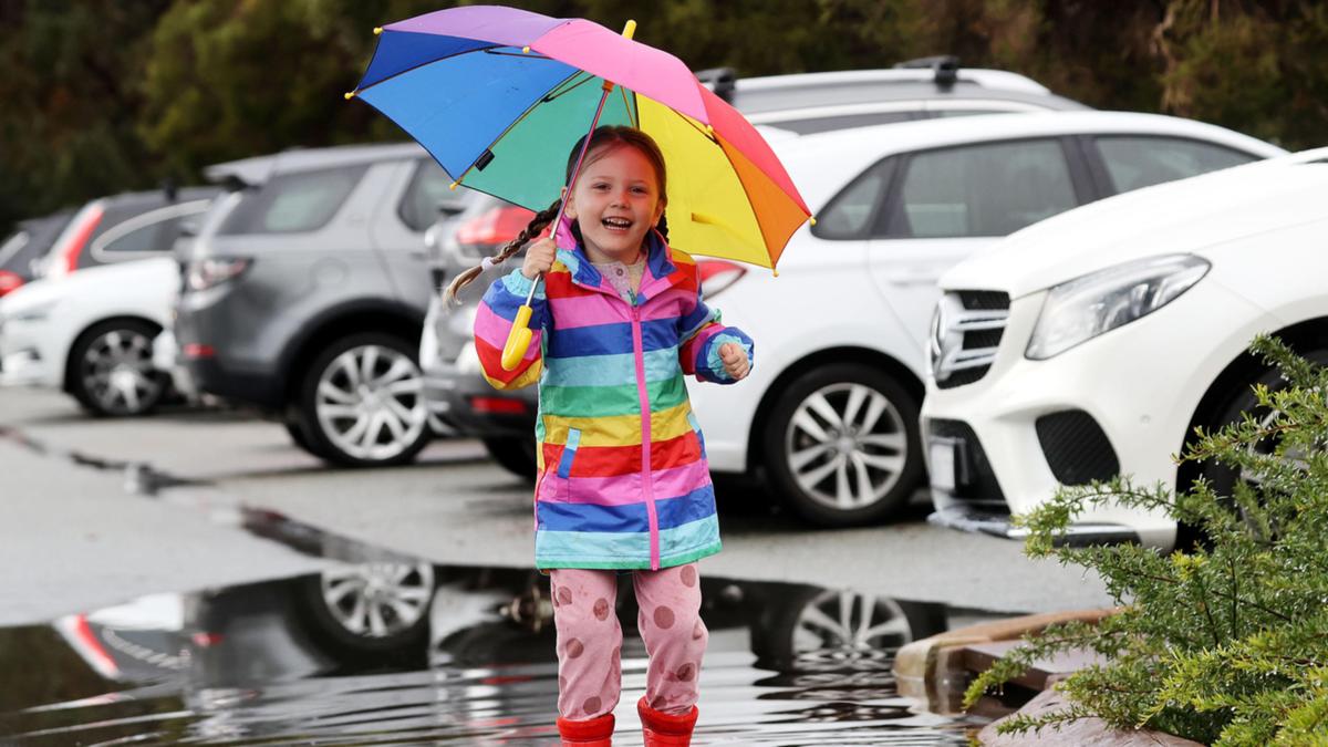
The snowfall came on what was also Perth’s coldest day of the year so far.
The city reached a top of 12.4C just before 4pm on Tuesday.
The chilly conditions come during one of the metropolitan area’s wettest ever starts to August.
Already the city has recorded 110mm of rain for the month so far, which is just shy of the monthly average of 122mm.
Last August only 56mm of rain was recorded.
Snow falls in Stirling Range National Park and Bluff Knoll as a cold snap hits Western Australia A toupee of fog, rolling over the mountain top. Credit: Anton Willk/Anton Willk
Perth can expect some sunshine over the next two days before the rain returns yet again over the weekend, and it looks set to continue into early next week.
Perth shivered through a cold snap on Tuesday as the city experienced its coldest day of the year so far.
It reached a top of just 12.4 degrees just before 4pm on Tuesday, blanketing Perth suburbs in an icy blast as the lowest temperature reached 9 degrees.
There has been 10.6mm of rain since 9am with Jandakot receiving the most at 40mm, according to the Bureau of Meteorology.
Perth has already had close to 121mm for the month of August in just nine days and should be on track to bet the monthly average of 122mm.
There is a 50 per cent chance of rain up until 8pm tonight with showers decreasing by 11pm.
Hikers in the State’s Great Southern witnessed snow fall atop Bluff Knoll, WA’s highest peak, in the Stirling Range National Park.
The short snow flurry dusted Bluff Knoll in white as hikers made the trek up the 1090m peak.
It was caused by a cold front that moved across Perth and the State’s south on Monday and Tuesday creating ideal conditions for a light amount of snow to fall on Tuesday morning.
Bureau of Meteorology duty forecaster Jessica Lingard told Perth Now on Monday that a “light dusting” of snowfall was expected in the region.
“We’ve got this cold front moving through today (Monday) and basically the cold front is aligned between two different air masses where you get warmer air in front of it and cold air behind it,” Ms Lingard said.
“I don’t think anybody is going to be building snowmen or skiing, but it will be a very light dusting.”
Snow was recorded at least five times last year in the Stirling Ranges, equaling a record set 53 years ago.
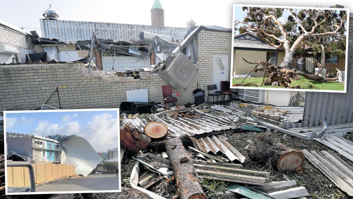
Homeowners trying to get storm-damaged properties repaired face massive waits as tradies are nearly impossible to hire.
The well-documented skills and supply shortages blighting the State have left people hoping to fix their houses wondering where to turn.
One roofing company said it had been inundated with 60 phone calls a day last week, while another said it was already booked out until next year.
The savage storms knocked out power to Perth Airport as well as 35,000 homes and wreaked havoc across Perth and the south-west last week, leaving a trail of damaged properties in their wake.
It’s not just homes that are affected. Canning Mosque in Queens Park was severely damaged during the storm when a large tree was uprooted and smashed into the prayer hall.
One of the walls was knocked down, part of the roof collapsed, structural beams were wrecked and flooding destroyed the interior.
Mosque president Bekir Serin said the damages were still being assessed by the insurance company, however, it was possible the Mosque would need to be demolished.
Amid the traditional shortages, and soaring labor and material costs, Mr Serin said the prospect of rebuilding was a big concern.
“It will be a serious challenge if we need to rebuild the Mosque. It won’t be cheap and it could take a long time,” he said.
The total cost of damages is still unknown, but a Go Fund Me has been set up to raise $1.5 million to aid construction.
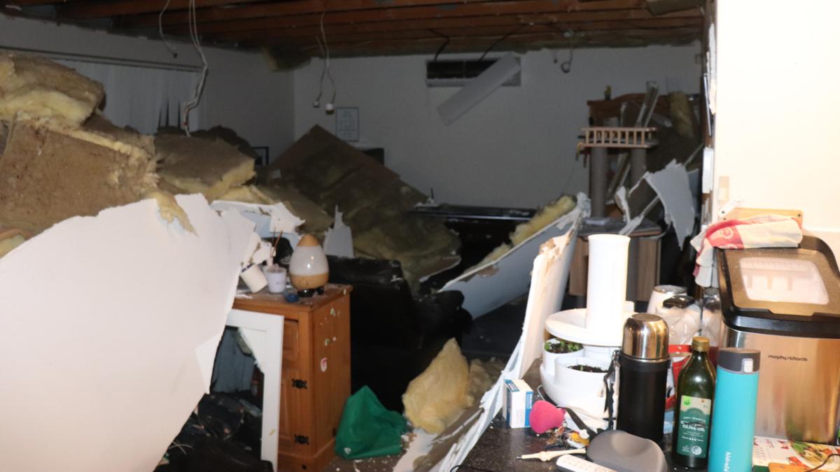
A ceiling collapsed inside a Joondalup house. Credit: 7NEWS/Supplied
There are warnings from within the construction industry about the prospect of cowboys swooping on desperate homeowners.
Chaley Kelly, from roof leak repair business Roofology, said in the past week she had been forced to turn away a lot of prospective clients, many of them elderly, because her company was already booked out until January.
Before closing its appointment book last month, the waiting list had grown to as many as 200 customers.
Mrs Kelly said she had noticed a troubling growth in the numbers of cowboy tradesmen operating.
She urged people to ask how long a company had been in business, and request a written quote outlining the scope of work, with photos taken before and after the repairs.
Storm damage on Discovery Crescent, Port Kennedy. Credit: Ian Munro/The West Australian
“We’ve seen some horror stories, so it’s important to ask some basic questions,” she said.
Shannon Hartfield, the general manager of Buss Roof Plumbing, aided the storms had sent his phone running off the hook, with about 60 calls a day.
Mr Hartfield said it had exposed the extent of shoddy workmanship on some newly built homes, with an astonishing 25 per cent of all storm damage-related repair work this week done on homes built in the past 12 to 18 months.
He said some of the basic errors included incorrectly installed gutters.
“Essentially, there are no falls on gutters — the gutters are falling the wrong way,” he said. “We are noticing gutters are being installed going up, rather than going down.”
He blamed increasingly rushed training, claiming some apprentices were being signed off before they were fully competent as the industry struggled to find enough workers.
A roof detached from a home on James Street. Credit: WA Incident Reports/Supplied
Jazz Monroe said her Ashby roofing contractor Upon The Roof was booked out for a month even before inquiries jumped by 100 per cent last week.
She said the delays caused by excess demand had been exacerbated by ongoing supply chain issues, including delays of up to eight weeks for gutters.
For the Johns Lyng Group — an emergency response builder contracted by insurance giant RAC — last week’s damage adds to a heavy workload which still includes some repairs from last year’s Cyclone Seroja in the Geraldton region.
General manager Daryl Carmody said the average weekly calls his company dealt with rocketed from around 300 to around 1000 after the storm, and he expected the volume to continue this week as people took stock of the damage.
SES workers in Port Kennedy. Credit: Ian Munro/The West Australian
He said all urgent repair jobs had already been given a temporary Band-Aid fix to stem further leaking or problems. But it would take months to properly repair some of the more serious damage, like collapsed ceilings.
RAC has lodged more than over 4,800 storm claims at a cost of $8.7 million, with the bill set to increase this week.
“We see this type of storm damage two to three times a year,” Mr Carmody said.
RAC home claims manager Glen Walker said the storm damage would also create additional demand for ceiling fixers, plasterers, painters and electricians.
For those who love the cold and have never seen snow before, Tuesday might just be your chance.
A cold front that will move across Perth and South West on Monday and Tuesday will create almost the perfect conditions for a light amount of snow to fall in the Stirling Ranges and on the top of Bluff Knoll on Tuesday morning.
Bureau of Meteorology duty forecaster Jessica Lingard said a “light dusting” of snowfall was expected in the region.
“We’ve got this cold front moving through today (Monday) and basically the cold front is aligned between two different air masses where you get warmer air in front of it and cold air behind it,” Ms Lingard said.
“The cold air behind today’s cold front is particularly cold and that means the upper-level air temperatures are very low.
“We need that level to be low enough so that when the snow falls out of the cloud it is not melting before it reaches the ground.
“Tomorrow morning, that situation comes about and conditions are looking good for a little bit of snow.
“I don’t think anybody is going to be building snowmen or skiing, but it will be a very light dusting.”
Snow was recorded at least five times last year in the Stirling Ranges, equaling a record set 53 years ago.
Snow at Bluff Knoll in 2019. David Readhead @davis_redman8 Credit: David Readhead
As for Perth, the city can expect to cop further heavy rainfall over the coming days.
Up to 15mm of rain is expected across the metropolitan area on Monday with a further 20mm tipped to fall on Tuesday.
The average amount of rainfall for Perth in August is 122mm. The city has already recorded 84mm.
“Considering we are only eight days in it wouldn’t surprise me if we got close or exceeded that average (over the next few days),” Ms Lingard said.
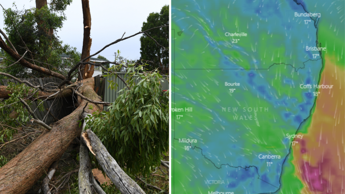
Floods, destructive winds and thunderstorms are expected to smash large areas across Australia’s south east as wild weather moves across the country from Western Australia on Thursday.
Wild conditions have already lashed much of southern Australia, uprooting trees and sending thousands of homes into darkness as the destructive conditions caused blackouts.
Watch more storm damage in the video above
Watch the latest News on Channel 7 or stream for free on 7plus >>
But the Bureau of Meteorology says little relief is on the way, with severe conditions expected to smash the country’s south east again as a second cold front moves in, with WA, SA, NSW, Victoria, and Tasmania in the firing line.
“Flooding rain, thunderstorms and dangerous winds will spread over southern and southeastern Australia during the next two days, with warnings in place for several states,” Weatherzone Meteorologist Ben Domensino said on Wednesday.
“A series of cold fronts and low pressure troughs are sweeping across southern and southeastern Australia this week as a large and complex low pressure system passes to the south of the country.”
The destructive conditions forced Perth Airport to use a back-up generator on Tuesday evening, after a high-voltage transmission pole was damaged.
The chaos plunged the airport into darkness as flights were delayed and canceled and frustrated travelers were left stranded.
Wild weather caused the ceiling of this Perth home to collapse. Credit: 7NEWSTrees were leveled across much of southern Australia as wild winds continued. Credit: 7NEWS
The damaging winds were felt across the country, with VIC SES receiving 399 calls for assistance in the 24 hours to midday Wednesday, mainly over fallen trees.
Meanwhile, emergency services in WA answered more than 440 calls for help since Tuesday afternoon and another 51 in the 24 hours to Tuesday night and 10 on Wednesday morning for SA SES.
Wind gusts hit a whopping 120km/h in WA on Wednesday morning at Cape Leeuwin, meanwhile SA’s Neptune Island recorded the state’s peak of 104km/h.
Mount William in Victoria was smashed by winds of up to 122km/h and NSW experienced its highest gusts of up to 107km/h at the snow mountains.
Wild weather to come
Looking ahead, BOM is warning damaging winds and dangerous surf are likely to hit SA, VIC, TAS, NSW and the ACT, as windy conditions finally ease in WA.
A second in a series of cold fronts will move through southern Australia on Thursday and is expected to bring heavy rainfall and potential flooding for northeast Victoria and south-east NSW, meteorologist Dean Narramore warned.
“Last night we saw a very strong cold front move through South Australia and Victoria and that brought damaging winds to numerous locations,” he said.
“But it is this next cold front that has got a link to tropical moisture that is really going to bring our heavy rainfall threat as we move into tomorrow.”
Trees down in Victoria. Credit: 7NEWS
Winds were expected to temporarily ease in SA on Wednesday night before re-intensifying on Thursday, with a severe weather warning in place for damaging winds across most districts.
Locations which may be affected include Adelaide, Port Lincoln, Whyalla, Mount Gambier, Ceduna, Port Augusta, Port Pirie, Clare, Maitland, Murray Bridge, Kingscote and Naracoorte.
Damaging winds are set to re-develop over the eastern ranges in VIC on Wednesday night, with heavy rainfall expected on Thursday.
A severe weather warning is in place for parts of East Gippsland, North East and West and South Gippsland Forecast Districts, and a flood watch has been issued for parts of the state’s northeast.
In NSW, damaging winds will continue over the south east, with gusts stronger than 125km/h likely to continue for alpine areas.
Lashings of rain which may lead to flash flooding could develop across the Snowy Mountains and the South West Slopes from early Thursday morning and the northern parts of the Central Tablelands from Thursday afternoon.
A flood watch is current for inland NSW central and southwest catchments.
Winds of up to 90km/h are expected in TAS, as VIC expects dangerous likes of 110 to 130km/h.
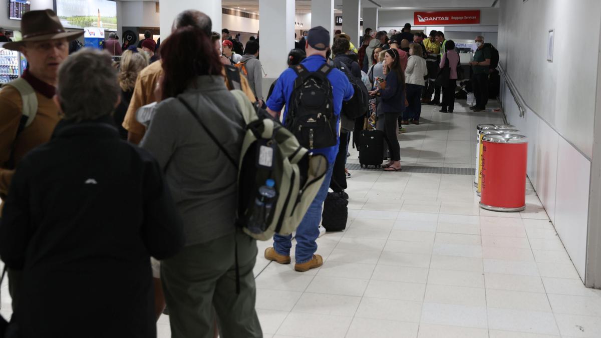
Perth Airport is in chaos after desperately trying to recover from a total blackout because of the severe storms crossing the State.
Flights were up and running but there was a huge backlog with passengers attempting to get through security.
Hundreds of people in high-vis were at Terminal 2 as regional flights were taking off. The line to get through to security was almost out the door as people raced to make their flight on time.
Terminal 1 was less chaotic, almost a ghost town in comparison, as several flights were still cancelled.
An airport spokeswoman said the terminals were “fully operational” as of 10pm last night but the flow-on effects of the impact could still be felt.
Perth Airport has announced a thorough review of its backup power systems in light of the power disruption.
While the backup power for the critical runways switched on, terminals were thrown into disarray chaos as backup power failed to come on.
Chief executive Kevin Brown said the review would start immediately to understand why parts of the back-up generation system did not deploy.
“We apologize for the inconvenience the power outage caused to passengers and we thank them for their patience and understanding that we were dealing with a unique and challenging weather event,” he said.
“The back-up generation system for critical safety systems such as the runway lighting worked as intended, meaning that aircraft could continue to land safely throughout the event.
“Other parts of the back-up generation system that provide power to the terminals did not work as intended.
“We need to understand why that happened.
Perth Airport has experienced a major power outage. Justin Benson Cooper Credit: Justin Benson Cooper/The West Australian
Thousands of passengers were disrupted overnight with dozens of flights delayed or cancelled.
The airport told its passengers to go home and declared all flights were canceled due to power outages “out of their control”, but by 8pm on Tuesday, changed its mind.
“With critical services back online, Perth Airport is now able to process some passengers through the outbound security processes,” a statement said.
“However it will take some time to clear the backlog of delayed services.”
By 10pm, the airport said it was working to activate its systems across its terminals in order to become fully-operational following delays and cancellations across the airline networks.
Passengers were warned some airlines could still decide to cancel and reschedule flights. “We ask passengers for their continued patience as our team and our airline partners work to get flights underway,” the airport said.
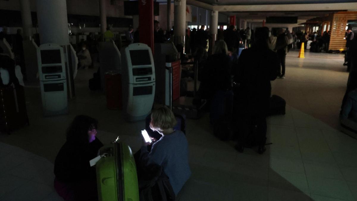
Travelers were left sitting in the dark with only torches to light their way.
Severe storms hitting Perth shut all the power down at the airport in what some experienced staff have never seen before.
Disgruntled passengers battled with freshly unloaded luggage as torrential wind and rain pelted them as they left the airport to board taxis.
Perth Airport announced the news about 5.15pm, warning that a power outage would result in lengthy delays for the next two hours.
The airport apologized to passengers, some of whom are understood to be stranded at other airports because they’re unable to land in Perth.
Perth Airport has experienced a major power outage. Picture are Angela and Han Nguyen Justin Benson-Cooper Credit: Justin Benson Cooper/The West Australian
“The safety of everyone who works in or is traveling through our airport remains our highest priority,” the airport said.
“We apologize to our passengers and customers for any inconvenience.”
Perth Airport said the decision to cancel flights earlier in the evening was made based on the advice of Western Power.
“Perth Airport has made the decision to delay all outbound services currently scheduled to depart before 7.30pm,” the statement said.
“All enroute inbound flights will be able to arrive safely. All scheduled flights into Perth which have not yet departed will be delayed until further notice.”
Hundreds of people were still crowding around baggage carousels at 7.30pm waiting for luggage to be unloaded from aircrafts.
Passengers in the Qantas terminal were reminded to stay patient while a “technical issue” prevented people from rebooking flights, as staff handed out water and chips to affected travellers.
A team in Sydney is currently working to “uncheck” passengers so flights can be rebooked. “Please be patient and go home, rebook from home as I’ve been advised delays could take up to another two hours,” staff announced.
Qantas Passengers Angela and Han Nguyen hoped to be on a flight to Sydney for a three-day work event.
Ms Nguyen, who is pregnant, said at about 3pm they were aware of flight delays.
Perth Airport has experienced a major power outage. Justin Benson Cooper Credit: Justin Benson Cooper/The West Australian
“We were Sitting in the lounge upstairs getting notifications from staff that it was out of their control and they had no idea what was happening,” she said.
“Staff working for 20 years told us they’d seen nothing like this.”
While “disappointed”, the couple said they were glad they could return to their Attadale home.
The lights came back on shortly before 7pm.
Passengers were told to leave as soon as their bags were collected and Perth visitors were told to find their own accommodation. Car park shelters were packed, as people waited to be picked up by transport services.
Melbourne woman Caren Vidler said she had no idea what to do as she frantically tried to find a bed for the night.
She was on her way to London when she was stopped at immigration and told her flight was cancelled.
“I’m going to watch some friends, who are divers, compete in the Commonwealth Games,” she said.
“I’ll be gutted if I can’t watch them, this was the whole purpose of my trip.”
“I’ve never experienced this before, I don’t know anyone in Perth…I’m going to need a bed for the night.”
Western Power says emergency crews are working hard in difficult conditions to restore power across Perth.
“Damaging and destructive winds associated with the front have thrown debris, including tree branches, into the network, damaging equipment and bringing down powerlines,” a spokesperson said.
“Our priority during the storm is responding to reported hazards to ensure the safety of the community and our crews.
A power outage has delayed flights at Perth Airport. Credit: Lincoln Baker/The West Australian
“Our network operations team is working to isolate damaged parts of the network and back feed where possible to restore power where it is safe to do so.”
It comes as Perth braces for more damaging winds set to smash the State after thousands were left without power and properties damaged overnight.
On Tuesday night, 11,000 homes in Perth and the South West remained without power.
The Bureau of Meteorology has issued a severe weather warning for Goldfields, Eucla, Lower West, South West, South Coastal, South East Coastal, Great Southern, Central Wheat Belt and parts of Gascoyne, South Interior and Central West districts.
A strong wind warning is also in place for Melville Waters and the Gascoyne Coast.
These winds are forecast to continue through to dawn on Wednesday and the Bureau has warned that wind likes may cause damage to homes and property, particularly along the coast and nearby inland, becoming more isolated further inland.
Perth has endured a second night of gale force winds and sideways rain as another monster cold front smashed the southern parts of the State.
Power blackouts are continuing to cause headaches with Western Power reporting 74 known outages affecting 8,100 customers – 4,200 in the metropolitan area and 3,900 in regional areas and in the South West.
Many of those people can expect to be without electricity until at least Wednesday afternoon.
A large tree lies across the road in Maddington after strong winds brought it down overnight. Credit: 7NEWS/7NEWS
Perth Airport was sent into chaos on Tuesday night after the power went out for hours, delaying check-ins and flights after a high-voltage transmission pole was damaged.
Flights were back up and running on Wednesday morning but the airport was backlogged with passengers attempting to get through security, with the flow on effects of the impact still being felt.
Hundreds of people in high-vis were at Terminal 2 as regional flights were taking off. The line to get through to security was almost out the door as people raced to make their flight on time.
A Western Power spokeswoman said crews and the network operations center worked through the night in difficult circumstances to make hazards safe and restore power where they could with around 1000 homes restored during the night.
“While further hazards and faults were reported overnight, storm-related damage to infrastructure was less than experienced yesterday where a peak of 35,000 customers experienced interruptions to their power supply.”
Houses damaged due to severe weather in Port Kennedy overnight. Credit: 7NEWS/7NEWS
All available crews are working to restore power however the spokesperson warned there may be some homes and businesses that experience an extended outage due to continuing bad weather.
“Damaging and destructive winds associated with the front experienced during the last 24 hours have thrown debris, including tree branches, into the network, damaging equipment and bringing down powerlines.
“Our priority during the storm is responding to reported hazards first before we repair and restore.”
Homes have also copped a lashing, with damaged roofs and fallen trees blocking roads.
There are report a ceiling has collapsed at a property on Lakeside Drive in Joondalup and emergency services are responding to storm damage in Maddington.
Houses damaged due to severe weather in Port Kennedy overnight. Credit: 7NEWS/7NEWS
In the South west, power lines are down in Margaret river with reports of lines down on Railway Terrace and Wallcliffe Road and Ashton Street and Nebbiolo Place.
A severe weather warning remains for Perth and the southern parts of WA. Stormy conditions are set to ease later this afternoon.
Large swathes of South Australia, Victoria and Western Australia were battered by wild winds overnight on Tuesday, leveling trees and leaving homes without power, with no reprieve expected until Sunday.
Potentially destructive winds have been forecast for much of southern Australia as a series of cold fronts moves across the country.
Severe weather warnings are current for parts of WA, SA, NSW and Victoria, as several locations gear up for a trifecta of damaging winds, heavy rainfall and flooding.
Watch the latest News on Channel 7 or stream for free on 7plus >>
In NSW the BOM is warning of damaging winds and heavy rainfall across the Illawarra, South Coast, Southern Tablelands, South West Slopes, Snowy Mountains and Australian Capital Territory forecast districts.
Blizzard conditions are possible in Alpine areas above 1900m, and the BOM is also warning of damaging wind gusts up to 90km/h in the state’s west.
The Victorian SES received 216 calls for assistance in the 24 hours to 6am Wednesday, mainly over fallen trees.
The busiest volunteer units were Emerald (24 calls), Pakenham (19) and Upper Yarra (15), with about 17,000 households in the Emerald and Pakenham areas without power.
VIC SES chief officer of operations Tim Wiebusch told Sunrise only a small percentage of trees had fallen onto structures.
“The problem has been trees across the road, and so I can’t emphasize enough this morning, be cautious, be alert to conditions when driving to work,” he said.
Trees down in Victoria. Credit: 7NEWSSES crew clear up trees that have fallen near properties and on roads in Victoria. Credit: 7NEWS
Watch and act warnings have been declared for The Great Dividing range, with residents in the area urged to prepare to take shelter.
However, the severe weather warning for Central Highlands and Mount Dandenong has now been cancelled.
Gusts in the Grampians reached almost 110km/h overnight, with Melbourne’s northern suburbs expected to be hit with wild winds later today.
Damaging winds averaging 65km/h with peak gusts up to 110km/h are occurring over elevated areas of Victoria’s eastern ranges, which are expected to ease on Wednesday afternoon.
However destructive gusts are expected to re-develop in the southwest of Victoria during Wednesday evening, with wind speeds averaging 50-60km/h expected and peak gusts of 90km/h.
Heavy rainfall is predicted in coming days across much of southern Australia. Credit: BoM
WA SES was called to 345 jobs in the past 24 hours to 6:30am Wednesday morning, 300 of those in the metro area.
Damage has occurred from Butler in the north of Perth to Mandurah on the southwest coast.
Most calls were related to fallen trees on roofs, damaged power lines, with some reports of patios and verandahs being ripped from homes.
There has also been one report of a roof that has collapsed in Joondalup.
According to the Bureau of Meteorology, a series of vigorous cold fronts will continue to cross the south of WA through to early Thursday.
Gusty showers and thunderstorms are likely along these fronts, as well as in the westerly flow in their wake.
Those in the Goldfields-Midlands, Midwest-Gascoyne, Perth Metropolitan, South West, Lower South West, Great Southern have been warned to take action.
South Australia’s SES received 51 call outs in the 24 hours up until Tuesday night, with another 10 received on Wednesday morning.
Most were pertaining to fallen trees, however none have created any significant damages to property.
SA SES told 7NEWS.com.au the state was not hit as hard as it was initially forecast.
SA Minister for Human Services Nat Cook has announced a code Blue has been introduced from Wednesday across the metro Adelaide due to the weather, meaning homelessness services will visit known rough sleeper locations to make people are aware of available support.
“Code Blue continues in regional centers until 9 August in the Riverland, Limestone Coast, Victor Harbor, Kangaroo Island, Port Lincoln, Clare, and Kadina,” she wrote on Twitter.
Strong to damaging northwesterly winds averaging 50-65 kilometers per hour with peak gusts of around 90km/h, are still possible across parts of the warning area during Wednesday afternoon and early evening.
The risk of severe winds will ease Wednesday evening, but conditions will remain comfortable near some coastal areas throughout the night.
Conditions are expected to ease across southern Australia this Sunday.
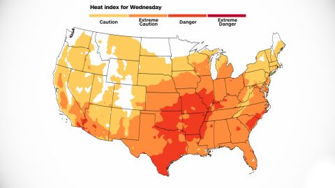
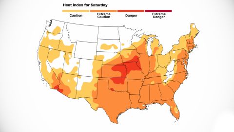
Two rounds of excessive heat will grip a large part of the country this week, impacting people from the Plains to the Midwest and the Northeast.
Heat advisories are in place for more than 30 million people from Oklahoma and Arkansas to Minnesota.
“Daytime highs will likely reach into the upper 90s to low 100s, and heat indices perhaps reaching 110 degrees when combined with high dewpoints,” the Weather Prediction Center said in its morning discussion Tuesday.
This heat will spread eastward, impacting the Northeast by the end of the week, then another round of heat will hit the Plains once again.
Between the waves of above-average heat, a bit of relief will come as cooler air pushes through.
Here is when to expect the heat and the minor relief.
“Dangerous heat indices expected today across much of central and southern (Minnesota) with afternoon heat index values expected to top out around 105 degrees,” warned the National Weather Service office in the Twin Cities in Minnesota.
Heat index values – the temperature it feels like when heat is combined with humidity – are for shady locations, the weather service explained. “If you are exposed to direct sunlight, the heat index value can be increased by up to 15 (degrees).”
The weather service breaks down the heat index temperatures into four different risk levels based on how heat index temperatures could affect the body. Danger, the third of four categories, is for forecast heat indices reaching 103 to 124 degrees. At this level, heat cramps or heat exhaustion is likely, and heatstroke is possible with prolonged exposure and/or physical activity. The maps below show the forecast dangers (dark orange) this week.
The heat will be felt much farther and wider than in Minnesota.
CNN Weather
An area of high pressure sitting over the Great Lakes is creating bright sunshine. But it’s also resulting in warm, moist air from the south to spill into the region.
Plainly put: High pressure is making it hot.
It is generating above-normal temperatures for such a large area in the midsection of the country. “Today looks to be the hottest day of the week,” said the weather service office in Wichita, Kansas.
Here, temperatures will also top out around 100 degrees. But once you factor in the humidity, it will feel closer to 105 degrees in some areas.
In southern Nebraska, it will feel even hotter.
“Heat index values are now forecast to climb as high as 110 degrees in eastern portions of the area,” said the weather service office in Hastings.
There may be one saving grace – a nice breeze.
“The good news is that south winds of 10-15 mph with gusts up to 25 mph will help combat the oppressive heat,” the weather service said.
The heat will even affect Kentucky, where the horrific flooding happened less than a week ago.
CNN Weather
High temperatures are expected to climb into the lower 90s Wednesday and Thursday, proving challenging for those still living without power from the floods.
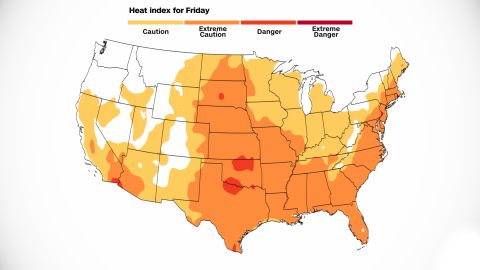
The heat will march on to the Northeast by the end of the week, giving the region a small window to cool down.
CNN Weather
For Washington, DC, and New York, the extreme heat will peak on Thursday and Friday. The weather service office in Washington mentioned in its morning discussion the forecast models favor “highs in the mid-90s which carries heat indices into the 100 to 104 degree range.”
New York City could even feel like 100 on Thursday and Friday, not able to escape the sweltering heat.
Its weather service office warned a heat advisory could be issued for those days.
By Saturday, a cold front will swing through the Northeast, bringing the potential for heavy rainfall and a temporary improvement in temperatures.
CNN Weather
After a brief reprieve, another round of heat will quickly hit the same areas as the first, sending high temperatures soaring once again.
“Friday looks to be the next chance of widespread 90s across central/southern Minnesota,” said the weather service office in the Twin Cities.
While this round may not last quite as long as the first, the heat will be just as potent.
“The center of the upper ridge looks to be situated over Kansas during the weekend ensuring the return of triple-digit heat to many areas,” the weather service said.
CNN Weather
By Saturday, another cold front will move through the area, helping to drop temperatures out of the triple-digit range and return them to more seasonal norms.
Saturday’s highs – back in the low 80s for Minneapolis – sound almost refreshing compared to heat indices in the triple digits.
While the Midwest starts to cool off, the second wave of heat will push into the Northeast by the beginning of next week.
“This wave looks to reach the Northeast by Sunday with another brief wave of high temperatures expected to continue ahead of a cold front into Monday,” the Weather Prediction Center said Tuesday.
Air traffic has ground to a halt at Perth Airport after severe storms caused a power outage on Tuesday evening.
Perth Airport announced the news about 5.15pm, warning that a power outage would result in delays for the next two hours.
The airport warned of lengthy delays and apologized to passengers, some of whom are understood to be stranded at other airports because they’re unable to land in Perth.
It said the decision was made based on the advice of Western Power.
“Perth Airport has made the decision to delay all outbound services currently scheduled to depart before 7.30pm,” the statement said.
“All enroute inbound flights will be able to arrive safely. All scheduled flights into Perth which have not yet departed will be delayed until further notice.”
Travelers were warned to expect delays or even canceled flights.
A power outage has delayed flights at Perth Airport. Credit: Lincoln Baker/The West Australian
“The safety of everyone who works in or is traveling through our airport remains our highest priority,” the airport said.
“We apologize to our passengers and customers for any inconvenience.”
Western Power crews are on site working to repair the damage.
Western Power says emergency crews are working hard in difficult conditions to restore power across Perth.
“Damaging and destructive winds associated with the front have thrown debris, including tree branches, into the network, damaging equipment and bringing down powerlines,” a spokesperson said.
“Our priority during the storm is responding to reported hazards to ensure the safety of the community and our crews.
“Our network operations team is working to isolate damaged parts of the network and back feed where possible to restore power where it is safe to do so.”
It comes as Perth braces for more damaging winds set to smash the State after thousands were left without power and properties damaged overnight.
The Bureau of Meteorology has issued a severe weather warning for Goldfields, Eucla, Lower West, South West, South Coastal, South East Coastal, Great Southern, Central Wheat Belt and parts of Gascoyne, South Interior and Central West districts.
A strong wind warning is also in place for Melville Waters and the Gascoyne Coast.
These winds are forecast to continue through to dawn on Wednesday and the Bureau has warned that wind likes may cause damage to homes and property, particularly along the coast and nearby inland, becoming more isolated further inland.