Mandarins are providing a much-needed source of income for citrus growers in South Australia amid a tough season.
Key points:
A Riverland citrus company says they can’t keep up with demand for mandarins
Flooding on the east coast and cold weather has affected citrus supply
Domestic demand has fueled sales for fruit unable to be shipped overseas
With flooding affecting many areas on the east coast, mandarins from the Riverland region have been filling supermarket shelves across the country.
Venus Citrus managing director Helen Aggeletos said demand had been outstripping supply.
“Mandarin volumes in general have been lower this year, both from Queensland and in the southern states as well, except for the Afourer variety,” she said.
“Basically we’re packing as much as we can.
“The only time there was a bit of a low was during school holidays, because mandarins are a bit of a lunch box fruit.”
The high demand for the fruit was fortuitous as it came after 14 outbreaks of fruit fly infestation in the Riverland and disruptions to the shipping industry.
So, Venus Citrus was able to redirect mandarins to the domestic market.
Ms Aggeletos said mandarins had also escaped albedo breakdown which unusually cold conditions had caused in oranges, making the skin softer and able to rot more easily.
“[Mandarins have] been good, and that’s probably been one of the positives in the scheme of things,” she said.
Citrus appeal during cold winter
Citrus Australia chief executive Nathan Hancock said the cold weather had helped drive sales.
“Of all the fruits out there at this time of year there’s plenty [of citrus] for Australian consumers to get their hands on,” he said.
“And it’s also really closely associated with boosting your immune system during winter.”
The end of lockdowns has coincided with an increase in winter citrus sales.(Rural ABC: Cherie von Horchner)
Mr Hancock said more people back in the office and at school after COVID restrictions had also helped the industry.
“Lots of citrus is used in hotels and restaurants and even juice bars that during [the] COVID-19 [pandemic] were really badly affected,” he said.
“So lemons, limes, grapefruit all suffered during that time because there just wasn’t the market for them.
“People are going out for dinner, and going to bars, [where they are] having a couple of slices of grapefruit, limes, or lemons in their cocktails and beers. And that’s really kickstarted those markets again, which is great.”
Tens of thousands of fraudulent flood assistance claims have been made this year, with more than $10 million dollars in support denied.
Key points:
There have been 3.5 million claims for flood support between February 28, 2022 and July 31, 2022
There have been more than 27,770 claims that have raised suspicions
More than 793 criminal investigations have been launched into suspected fraudulent claims
Payments have been offered to people impacted by floods in New South Wales and South-East Queensland in February and the recent Sydney floods in July.
Government Services Minister Bill Shorten has raised concerns that, while money is being offered to those who need it, others are taking advantage of the system.
“I believe that the taxpayer-funded safety net needs to go to those who need it and it really makes my blood boil when I think that there are some people out there taking advantage of other people’s misery to steal $1,000,” he said.
“What is going on with people? How can people think like that?”
The support on offer includes the Australian Government Disaster Recovery Payment of $1,000 per adult and $400 per child, as well as the Disaster Recovery Allowance which provides 13 weeks of support at the rate of the JobSeeker allowance.
About 3.5 million claims have been made for assistance between February and July following the floods.
Bill Shorten says it is important fraudulent claims are detected. (ABC News: Nick Haggarty/File)
Of those, there have been 27,770 cases that appear to be suspicious and about $10.5 million in support has been denied.
Mr Shorten said it was important that all fraudulent claims were picked up by the system.
“I’m very mindful that this is taxpayer money and I’m mindful that taxpayers are happy to help their fellow Australians in trouble,” he said.
“But they do expect government agencies to be as careful as they can separating the legitimate from the illegitimate.”
Mr Shorten said he was concerned there had been, or could still be, opportunistic behavior that was “robbing” from flood victims.
“I’m asking Services Australia: ‘Are we catching everyone?'” he said.
“I want to make sure that our detection systems for fraud are what they should be, and anything other than that undermines public confidence in the provision of support for victims.”
He said there were now 793 criminal investigations underway.
More than $1 billion has been handed out to Australians this year in flood support.
Space to play or pause, M to mute, left and right arrows to seek, up and down arrows for volume.
Probe finds lead emergency agencies failed in flood response.(ABCNews)
Heavy rains have brought flooding to parts of Tasmania, with flooded roads and emergency crews kept busy — but weather forecasters say the worst has passed.
Key points:
A number of severe weather warnings are in place for areas of Tasmania
Roads have been closed and electricity cut due to downed powerlines
The BOM says the worst of the rains have passed
Thousands of people were without electricity on Sunday morning, with Tasmania’s electricity utility TasNetworks reporting outages in Eaglehawk Neck, Highcroft, Koonya, Nubeena, Port Arthur, Premaydena, White Beach and surrounds “believed to be weather related”.
At 10am, the SES’s Leon Smith said there had been 40 call outs for “minor flood damage”.
“Things like water coming in through rooves, gutters overflowing, and water coming into homes.”
He said the calls starting coming from the northern suburbs and Greater Hobart area, but “as the system is moving south, crews are now active in the Huonville and Franklin areas.”
Mr Smith said there was “potential for thunderstorm activity”.
The SES will hold a press conference at 1pm today to update the situation.
A wet scene at Mountain River, south of Hobart.(Supplied: Kinnan Brightman)
The Bureau of Meteorology’s Deb Tabor said “certainly, the worst of it has happened.”
“But it will still be wet for the rest of the day, particularly in the east and south the winds will start to ease off, and they will get a little bit gustier in the afternoon on the east coast.
“Up to 9am this morning, the highest rainfall has been kunanyi/Mt Wellington at 109mm.”
Ms Tabor said there had been 91mm of rainfall at Nugent, 71mm at Mt St John, 68mm at Gray in the north-east, 67mm at Buckland and 56mm in Fern Tree.
Water has cut roads in the flood-prone area of Huonville, 38 kilometers south of Hobart, with Tasmania Police advising the Esplanade is closed due to water from the Huon River over the roadway.
Some residents have reported sandbagging their homes on Flood Road, with assistance from SES volunteers.
Tasmania Police are updating their list of road closures due to the weather.
In Baghdad, 37 kilometers north of Hobart, roads were flooded and residents watched as waterways swelled.
A resident in the town said the “rain was very heavy and the water came up really fast from the time I got up at seven till now”.
“We flood a bit in winter but this is crazy and seems to be getting worse every year.”
Space to play or pause, M to mute, left and right arrows to seek, up and down arrows for volume.
Heavy rains hit Tasmanian orchard at Grove
loading
A Cygnet resident said she had “not seen this kind of rain for about 17 years.”
“Last time it washed away our little water crossing at the bottom of our street, this morning it’s starting to overlap that crossing.
“It’s incredible how much water is coming down the creeks, our rain tanks were nearly empty yesterday and today they’re overflowing.”
Stay up to date with the latest warnings on the Bureau of Meteorology’s weather warnings for Tasmania website.
Aurora and Violet could see the bright side of the gloomy weather in Huonville.(ABC News: Daniel Miller)
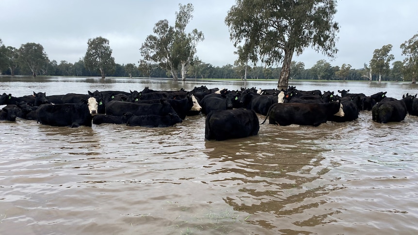
Farmers who lost livestock due to flooding along the Murrumbidgee River say water management by dam operators has made the event worse than it needed to be.
Key points:
Murrumbidgee River landholders say they expect some flooding, but dam management has exacerbated recent flood events
A Borambola farmer, east of Wagga Wagga, lost dozens of calves and has cattle stranded by floodwater
Wagga Wagga MP Joe McGirr says dams should not be kept at such high levels, given the risk posed to downstream landholders and communities
The Murrumbidgee River reached moderate to major flood levels this week following releases of close to 100,000 megalitres a day from Burrinjuck Dam after record inflows from some parts of the catchment.
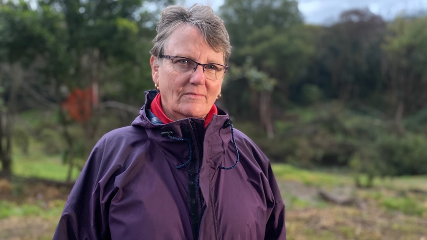
Borambola farmer Trish Cookson lost dozens of calves in the flood, with some washingup dead, and still has cattle stranded by floodwaters.
She said they could have managed the anticipated flows of up to six meters but they struggled with the larger than expected water release.
“We’ve made several attempts with boats, dogs, neighbours, trying to get the cattle out… it’s very heartbreaking,” Ms Cookson said.
She said living on the banks of the Murrumbidgee, they expected some natural riverine flooding, but keeping dams at such high levels during a La Nina year was “reckless.”
“I would say that it’s been mismanagement of the water storage facilities,” she said.
Ms Cookson says the flooding was due to mismanagement of water storage facilities.(ABC Riverina: Olivia Calver)
Ms Cookson said there were plenty of opportunities throughout the year for dam managers to lower dam levels.
Of the two Murrumbidgee storages, Burrinjuck Dam has not fallen below around 80 per cent this year, while Blowering Dam has not dropped far below 90 per cent full.
Floodwaters have spread across more than 30 per cent of Borambola farmer Trish Cookson’s property. (Supplied)
WaterNSW is in charge of dam operations and said Burrinjuck Dam filled and spilled due to inflows that were higher than forecast.
“The Yass River at Yass, in particular, experienced its highest flood peak since records began in 1915,” WaterNSW said in a statement.
“WaterNSW will make releases from rural dams well in advance of an event in order to create airspace and mitigate the impacts of future rain events.
“However, when storages are full WaterNSW has limited ability to mitigate floods.”
The storage level of Burrinjuck Dam on the Murrumbidgee River increased by 13 per cent last week.(Supplied)
Flooding impacts ‘seem to be ignored’
Independent Wagga Wagga MP Joe McGirr said he had been contacted by several landholders concerned about the dam management.
“The concern that landholders have expressed to me is when those levels are kept too high. The risk is when you get a sudden weather event… the dam spills,” Dr McGirr said.
Dr McGirr said he had brought the issue to the attention of NSW Parliament this week.
“It’s almost as though so much priority is given to the need for the irrigators to have their water and the environmental flows that the effects of flooding… seem to be ignored.”
Farmers say floodwaters came up unexpectedly fast following huge releases from Burrinjuck Dam. (ABC Riverina: Olivia Calver)
Fear of more flooding this spring
Ms Cookson said she was holding out hope that floodwaters would recede soon, but with a full catchment and wet spring predicted, any relief could be short-lived.
“I can only see that for every rain event that happens, we’re going to be plunged further and further into this quagmire that we’re in at the moment,” she said.
“I fear for those animals. We will continue to try and find a way to get them out.”
Murrumbidgee River landholders are also worried about the NSW government’s program to more effectively deliver environmental water to the Murray Darling Basin.
The Reconnecting River Country Program could see the river run at higher flow rates, potentially exacerbating natural flooding events.
“After having the water modeling done on our property, we know that the reconnecting river program is virtually going to make our property not a viable business,” Ms Cookson said.
“We have a billabong that cuts from one of our property to the other.
“At the higher flow levels that they’re predicting, we will not be able to access 34 per cent of our property.”
Farmers have used boats to try and rescue cattle stranded in floodwaters. (ABC Riverina: Olivia Calver)
The Department of Planning and Environment said current water levels seen across the Riverina were well above the flows being considered by the program.
“We take the views of landholders and stakeholders seriously, and we encourage them to have their say on the flood mapping and flow options to ensure we get it right,” a Department of Planning and Environment spokesperson said.
Residents living upstream from Lismore say faults in the rain and river gauge network deprived them of potentially life-saving data as a catastrophic flood hit the New South Wales Northern Rivers in February.
Key points:
Crucial equipment failed because it was poorly located, while key rainfall data was missed or distorted due to a lack of maintenance
Flood hydrologist Duncan Dey says the whole gauge network needs to be reassessed
A report into the floods found information from the Bureau of Meteorology was “incorrect and out of date”
There are 27 rainfall and 19 stream level gauges in the Wilsons River catchment that provide data to the Bureau of Meteorology to help predict flood heights and develop forecasts.
Residents also monitor the data directly via the bureau’s website.
When the February flood hit, one rain gauge was already broken and a further two rain gauges and six stream gauges stopped transmitting data during the event.
ABC’s 7.30 can reveal that crucial equipment failed because it was poorly located, while key rainfall data was missed or distorted due to a lack of maintenance.
When the February floods hit the Northern Rivers, one rain gauge was already broken and two more stopped transmitting data.(abcnews)
The revelations follow the release of a NSW parliamentary report examining the flood response, which found information from the Bureau of Meteorology was “incorrect and out of date”, and called for the bureau to review its rain data infrastructure to ensure rain and flood gauges were appropriately placed, maintained and updated.
Local resident Annie Kia says the failures of the gauge network caused “much distress” among her upstream neighbours, who were among the first to witness the scale of the disaster firsthand.
“The upstream people knew that a catastrophe was hurtling toward Lismore in the night, and felt very frustrated that they could not get their message across,” she said.
‘People downstream really need to know’
The gauges near Nan Nicholson’s home stopped working as floodwaters rose.(ABC News: Ella Archibald-Binge)
Nan Nicholson’s property is nestled in the hinterland north of the town, flanked by two creeks that feed into the Wilsons River catchment.
“If it’s torrential rain up above, we know that Lismore is going to really cop it,” she said.
As a low pressure system moved south on the night of February 27, she was keeping a close eye on the local rain and stream gauge data, which she and her neighbors rely on for real-time information to decide when to evacuate.
The stream gauge said the nearby creek was “steady.”
However, that was in stark contrast to what was unfolding in her backyard: The creek was rapidly closing in on her home, and the hammering rain showed no signs of easing.
She could see the flood was shaping up to be far worse than initial predictions of a peak around the 2017 height of 11.59 meters.
Rocky Creek, one of the feeder creeks upstream from Lismore.(ABC News: Ella Archibald-Binge)
“You could watch it within the minute rising very, very rapidly, so I just didn’t believe [the data]and that really filled me with dread,” she said.
“I thought, ‘People downstream really, really need to know this, and they’re not getting that information’.”
Ms Nicholson and her husband made a narrow escape in the night.
By the time they left, the nearby river gauge was not transmitting any data at all.
The rain gauge failed a short time later.
“Because of our knowledge of the area, we felt prepared to some degree, but it would have helped a great deal to know that that river gauge … was telling the truth,” she said.
“It’s a basic government responsibility to deliver us the data that we need to make decisions about our survival.”
‘Whole network needs to be reassessed’
Duncan Dey says rainfall modeling “only works if you’ve got good data”.(ABC News: Ella Archibald-Binge)
Duncan Dey is a flood hydrologist and Byron Shire councilor who used to install and maintain rain and stream gauges.
I have identified key flaws in the gauging station near Ms Nicholson’s property.
He said a shed housing equipment that sends data to the weather bureau should have been located on higher ground.
“We know that the shed went underwater, and I’m stunned, actually, because it went underwater by three or four meters, which means that it was wrongly located in the first place,” he said.
“The whole network needs to be reassessed for whether the machinery shed is high enough above the flood levels.”
Duncan Dey and Annie Kia inspect a rain gauge. Mr Dey was surprised to find a tree growing over the top.(abcnews)
Mr Dey said he was also “shocked” to see a tree overhanging the top of the rain gauge.
“So it’s not actually measuring the right amount of rain. It’s completely non-standard,” he said.
“We now have computer modeling that works really well on taking rainfall, putting it into a catchment and working out what happens downstream — the modeling is fantastic, but it only works if you’ve got good data.”
A BOM spokesperson said the outages did not impact the bureau’s forecasts and warnings during the February flood, and that redundancy has been built into the observation system.
However, the bureau is reviewing its infrastructure across the catchment.
Council requests more gauges
Lismore City Council general manager John Walker says the gauges are maintained every three months, or more often if a fault occurs. (ABC North Coast: Bruce MacKenzie)
The state gauge network is jointly managed by local, state and federal governments, along with some private agencies.
Lismore City Council owns the gauges that malfunctioned in February.
General manager John Walker said all but two of the gauges have been fixed, with parts on order from overseas, while one was broken prior to the flood because a technician could not get access to the site due to ground conditions.
Mr Walker said all existing gauges were located above the 1974 flood levels and the equipment that had been repaired has been relocated to higher ground, above the 2022 flood height.
He said the gauges were maintained every three months, or more often if a fault occurs.
The council’s request for more gauges, he said, was being assessed by the NSW Planning and Environment Department, after it was initially rejected in February.
A spokesperson for the department said it was awaiting completion of the council’s flood plain management plan before it could review the funding application.
Resident Annie Kia is among many — including local councils and MPs — calling for a single agency to own and maintain the gauge network.
“It’s clear to me that the system is not fit for purpose,” she said.
“We need to have some government system that manages these creek and rain gauges, and it seems to me it would be better if it was one agency — as long as it’s one, competent agency.”
A parliamentary inquiry has found the government agencies in charge of preparing for and responding to major flooding in New South Wales this year failed affected communities.
Key points:
A NSW parliamentary committee has found lead agencies failed to warn and protect communities
It is recommending the SES restructure to harness local knowledge, and that Resilience NSW be abolished
The weather bureau is also being told to consider reviewing its data
Seven people died and thousands of people were displaced or cut off when floodwaters devastated the Northern Rivers region twice since late February.
Despite calls from authorities to stand down, residents took to boats and jet skis to rescue each other from rooftops, and took with them axes and other equipment to cut open roof cavities in which people were stuck.
Led by Labor’s Walt Secord, the parliamentary committee took evidence at a series of hearings across the state’s north as well as Western Sydney, where floods also became deadly.
“The committee found that the [State Emergency Service and Resilience NSW] failed to provide leadership and effective coordination in the community’s greatest time of need,” Mr Secord told parliament as he tabled the report.
The NSW Parliamentary Flood Inquiry held hearings on the north coast in May.(ABC North Coast: Bruce MacKenzie)
The report found that information from the State Emergency Service (SES) and Bureau of Meteorology (BOM) was “incorrect and out of date”, leaving the community with “no other option but to ignore government advice and save lives”.
It made 37 recommendations, including that the SES, the state’s lead agency in a flood event, undergo a restructure to harness local knowledge and employ more salaried staff.
It urged the weather bureau to review its rain data infrastructure and flood modeling tools.
The report found the state agencies and BOM were “not prepared for, nor did they comprehend the scale” of the floods and that “some agencies were criticized for treating it as a nine to five business operation”.
Lismore resident Billy Curry was one of many in the “tinny army” who took it upon themselves to rescue people the day his home town went under.
He agreed there did not seem to be enough resources to assess and respond to the situation, and that without the impromptu volunteers “the community would have been in a lot of trouble”.
“There were scenes there where you were ducking under power lines and street lights in a boat,” he said.
“We lifted 64 older people from an elderly aged care place into a boat, so that’s something you don’t forget.”
Billy Curry wants a database created to better manage willing and able volunteers.(ABC North Coast: Bruce MacKenzie)
Mr Curry said he wanted the State Emergency Service to adopt a database of volunteers who had lifesaving skills and equipment such as jet skis, who could be quickly briefed via SMS in an emergency.
“Also, there was no management of knowing who was in the water and how many people were volunteering,” Mr Curry said.
“SW [no] database of managing the demand of incidences, that definitely stood out, it was absolute chaos.”
The committee has also recommended the NSW Government consider abolishing Resilience NSW, the disaster recovery agency set up in the wake of the Black Summer bushfires, currently led by former Rural Fire Service Commissioner Shane Fitzsimmons.
The inquiry is separate to an independent report, that the government has received but not made public, which the ABC understands will also recommend dismantling Resilience NSW.
Both the SES and Resilience NSW told the ABC they would consider the findings before responding to parliament.
A spokesman for the NSW Emergency Services Minister Steph Cooke said they did not know when the report would be tabled and that the minister would not be able to comment “until the NSW Government actually receives the report and has an opportunity to review and respond”.
The report findings include:
SES and Resilience NSW failed as lead agencies
SES was hindered by centralization and shortage of volunteers
SES issued out of date, inaccurate and confusing messages
Community members had no other option but to ignore government advice and save lives
Grants process was insensitive and compounded trauma
NSW Government agencies lacked coordination, created confusion
Demarcation disputes between NSW Government agencies slowed the roll-out of support
NSW Government failed to adequately prepare effective temporary and long-term housing solutions
Recommendations for NSW Government include:
Consider a restructure of SES to harness local knowledge, coordinate more closely with other rescue agencies, increase salaried staff and drive volunteer recruitment
Consider abolishing Resilience NSW
Appoint a senior police officer to lead recovery efforts
Prioritize the rebuild of Cabbage Tree Island
Significantly increase investment in flood mitigation and preparation
Could your home withstand a wild weather event? If you are feeling nervous about the next wet season, a $20 million state government scheme could help allay those fears.
Key points:
Home owners can apply for more than $11,000 from the state government to help protect homes from extreme weather
Roofing, doors, reinforcing windows among the improvements funded
Insurance premiums on some properties have been brought down by 8.5 per cent in previous rounds of the grant
Here is how you could get your hands on cash to help fund home improvements and bring down your insurance premiums.
The Household Resilience Program was first introduced in 2018 to help homes in flood and cyclone risk areas north of Bundaberg.
The initiative is targeted at low-income households to replace roofs and doors, reinforce windows and tie down external structures.
The government will provide up to $11,250, with owners required to stump up 25 per cent of the total cost.
Who is eligible?
To be eligible, your home must have been built before 1984 and located 50 kilometers off the coast in locations north of Bundaberg.
Your weekly combined household income must be less than $1,801 for a couple with a child or $1,050 for an individual.
Roof replacement has been one of the most popular improvements made as part of the scheme.(AAP: Dave Hunt)
Will the building industry cope?
While the construction industry has been plagued by delays due to unprecedented demand in recent years, the pipeline of work is now beginning to show signs of slowing down.
Master Builders Queensland regional manager Emma Peters said the timing was right.
“Those HomeBuilder residential builds are now very much a work in progress, if not coming towards the end of having those properties finished now,” Ms Peters said.
“So this is very welcome.”
The program is expected to provide a significant economic injection for the building industry.(ABC Midwest and Wheatbelt: Samille Mitchell)
The last phase of the Household Resilience Program injected $8 million into the Townsville economy alone.
“Last time, north Queenslanders wholly embraced the program; about 45 per cent of the entire program was actually spent here in the Townsville region,” she said.
John Wilkinson runs a roofing company in north Queensland.
He said the program generated significant interest in his business during the last round.
“Yes, well definitely it’s been good for business,” Mr Wilkinson said.
“The nature of quoting for the job is the same as any other; it’s just that the funding comes from the government.”
With the wet season fast approaching it is hoped works can be undertaken to provide added protection to home owners, while also bringing down insurance premiums that continue to cause pain to many household budgets in the state’s north.
State government data has shown those who have participated in the past schemes have seen a drop of 8.5 per cent in their premiums.
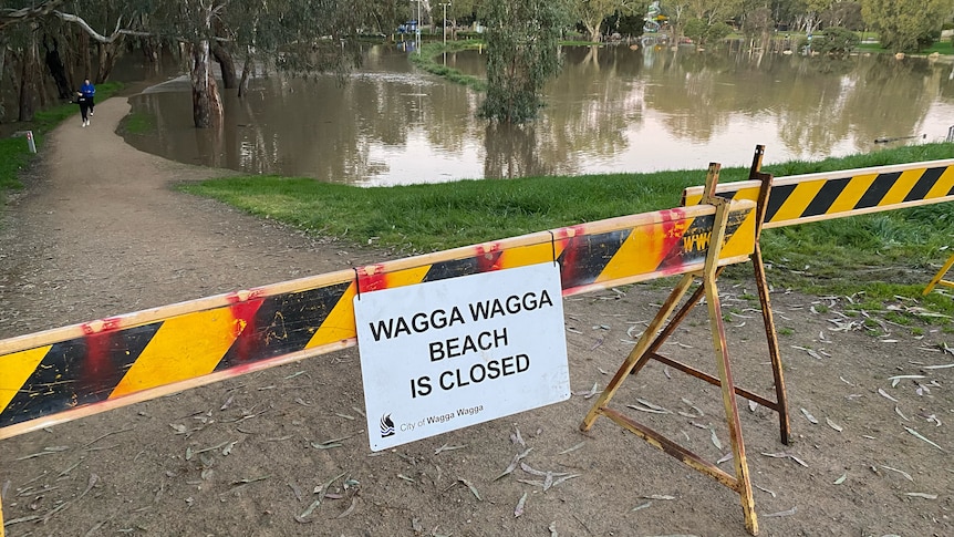
Residents in parts of Wagga Wagga in the New South Wales Riverina have been ordered to evacuate as floodwaters rise.
The State Emergency Service has told people in and around low-lying areas to leave before 6pm on Sunday evening, August 7.
The areas include:
• Edward Street West • Flowerdale Road •Roach Road • McNickle Road •Lower Gardener Street •Wilks Park • Eunony Bridge Road •Mill Street
The SES says once flood waters reach 8.7 meters at the Wagga gauge, roads will be cut and access to water and sewerage may be lost.
SES deputy southern zone commander Barry Griffiths said the order had been issued because of concerns roads would be cut off, rather than houses being inundated.
He said about 120 residents were affected by the order.
Barry Griffiths warns residents even shallow flood water is a hazard.(ABC Riverina: Romy Stephens)
“Essentially this one’s been done on the public safety issue,” he said.
“Properties should be OK at these levels but there are some areas of the North Wagga area, north of the Murrumbidgee River, that do experience quite rapid water moving through which is dangerous to motorists.
“Even shallow water is capable of killing.”
People who choose to stay after 6pm could be trapped without power and it may be too dangerous for the SES to rescue them.
Wherever possible, people should go and stay with family or friends but there is an evacuation center at Kyeamba Smith Hall, at the Wagga Wagga Showground.
The Murrumbidgee River is still rising at Wagga Wagga. (ABC Riverina: Gary-Jon Lysaght)
Farmer prepares for floodwater
John Keough, who owns more than 20 hectares on the floodplain near Flowerdale Lagoon, has prepared livestock and equipment to be moved if needed.
He said he was not overly concerned about his property being impacted.
“We’re on the river so it floods, it’s as simple as that,” he said.
“It’s a beautiful spot, beautiful soil and the reason is because you get floods so you just live with that.”
Moderate flooding is also possible at Narrandera from Tuesday.
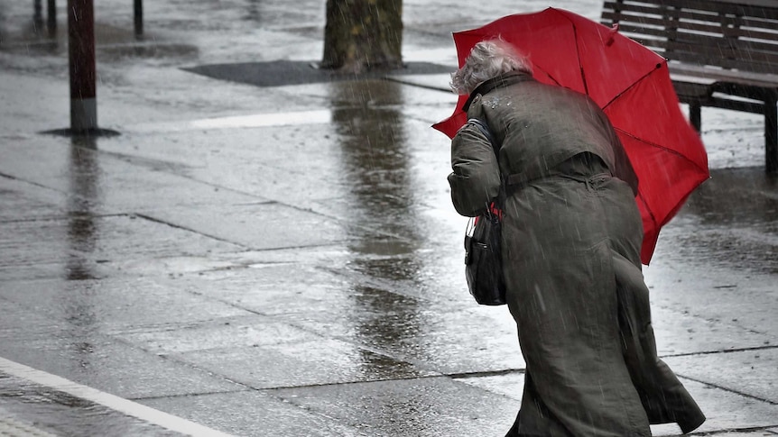
The weather is expected to keep getting wetter for inland NSW and Victoria’s alpine regions today as the biggest frontal system of the season sweeps through.
Key points:
Rain, wind and flooding forecast in NSW and Victoria alpine regions
The forecast comes as a series of cold fronts sweep across Australia
Warmer temperatures and rain are bad news for ski fields
The complex low pressure system is not being followed by the usual piercingly cold change, which is great news for those who are sick of shivering but a worry for the ski fields.
Why all the wild weather?
The first in a series of cold fronts moved through Western Australia on Monday, where some Perth suburbs were hit by their highest wind gusts on record and power outages caused havoc at the airport.
loading
The next swept across South Australia on Tuesday.
Today a third is sweeping across the south-east.
“That’s going to tap into some tropical moisture, leading to widespread rainfall across much of inland New South Wales and north-eastern parts of Victoria,” weather bureau meteorologist Dean Narramore said.
“The main band will really start to pick up on Thursday morning and then become widespread across New South Wales and north-eastern Victoria Thursday afternoon and Thursday night.”
He said the heaviest falls were expected west of the Great Dividing Range.
Heavy rain is expected over the next few days.(Supplied: Bureau of Meteorology)
“This is more of an inland rain event,” Mr Narramore said.
loading
He said more than 100 millimetres of rain could fall on Victorian alpine regions today.
“That could lead to minor to moderate flooding on some of our rivers, creeks and streams,” he said.
“So something to watch as you move through later into Thursday into Friday.”
Rain is also expected to continue over northern and western parts of Tasmania, where flood warnings are also current.
Wind impacts are not expected to be as bad as in the past few days.
But Mr Narramore warned likes of about 100 kilometers an hour were still likely through north-eastern parts of Victoria, particularly for alpine areas.
He said elevated parts of New South Wales were also at risk of strong winds, with likes of up to 125 kilometers an hour predicted in the Snowy Mountains.
Watch for warnings
Victoria State Emergency Service chief officer of operations, Tim Wiebusch, urged people to keep up with emergency information.
“Ensure you listen to the advice of emergency services, and secure loose items in and around your home, park your vehicle undercover, away from trees and remain indoors until the severe weather has passed,” he said.
“As we are expecting heavy rain in parts of Victoria, it’s important you never drive through floodwater.
“Attempting to drive through flood waters may be the last decision you make,” he said.
Bad news for the snowfields
Cold fronts are usually followed by a blast of icy southerly air. But this time around temperatures have remained remarkably balmy.
Mr Narramore said that it was because the large complex low had been blocking the cold air from coming up.
He said it had instead been stuck over the south-west of Western Australia.
“So large parts of WA are in that west or south-westerly stream behind the cold front and low pressure system, that’s directing the much colder conditions there,” he said.
“But for eastern parts of Australia, we’ve been in the north or north-westerly flow ahead of all these fronts.”
He said snow levels would be “really high”, probably just in the peaks.
Rain is the worst possible news when you are trying to maintain a snow pack.(Chris Hocking)
“The rest of our ski resorts, particularly in Victoria, might only see mostly rain,” he said.
The end is in sight
Conditions are expected to ease over Western and South Australia today.
“There will still be hit and miss showers continuing across much of the south-east on Friday,” Mr Narramore said.
“But this large, complex low pressure system will weaken as we move into Thursday and Friday.
“Most of the country should be fine and partly cloudy as we get into the weekend.”
Indigenous community leaders on the New South Wales far north coast say the emergency response to this year’s flooding disaster ranged from unprepared and uncoordinated to non-existent.
The Bundjalung Nation Flood Response Report was released to the public today after earlier being submitted to the Independent Flood Inquiry.
Some of the community leaders’ key findings included:
The emergency response was under resourced, unprepared, uncoordinated, and simply non-existent for many,
Woefully inadequate planning and environmental systems were not informed by First Nations science, cultural knowledge, and data; and
There was a lack of First Nations people and voices in government structures.
Currie Country Group’s report co-author Arrabella Douglas.(ABC North Coast: Bruce MacKenzie)
Report co-author Arrabella Douglas from the Tweed-based Currie Country Group was among those to speak at the release ceremony today.
“We have come together because we are black first,” she said.
“We are worried and concerned about our Aboriginal communities, and we are prepared to stand up and do it because if we don’t we know we will be overlooked.”
CEO of the Bogal Local Aboriginal Land Council Rebecca Woods.(ABC North Coast: Bruce MacKenzie)
Rebecca Woods from the Bogal Local Aboriginal Land Council struggled to contain her emotions as she spoke about the situation in nearby Coraki where about 60 people are still living in tents after their homes were inundated.
“We’ve still got people living in temporary accommodation solutions with no real strategy,” she said.
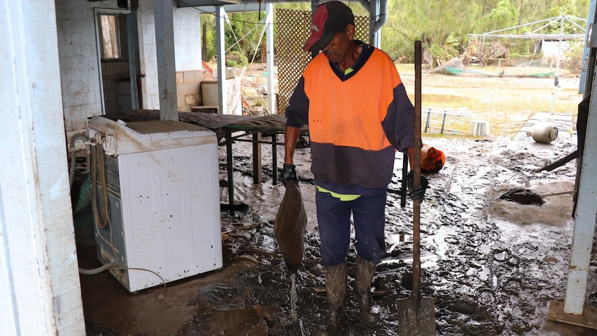
Dale Bolt cleaning up inside a house after floodwater damage at Cabbage Tree Island.(ABC News: Rani Hayman)
The community’s report made more than a dozen recommendations including:
Improve planning, flood mitigation, and environmental mapping processes by incorporating local First traditional Nations owners’ knowledge,
Improve emergency responses during and after natural disasters, and ensure First Nations voices are driving decisions,
Ensure crucial infrastructure is disaster-ready for future events; and
Build the capacity of Aboriginal organizations to function and respond in times of natural disaster.
Chris Binge, CEO of the Jali Local Aboriginal Land Council.(ABC North Coast: Bruce MacKenzie)
Chris Binge, who helped to rescue more than 200 people from Cabbage Tree Island at the peak of the crisis, urged the government to take note.
“If government can’t keep up with us we will do what needs to be done because that’s the sort of people we are,” he said.
“Leadership is about listening, it’s about learning from what’s happened and also what didn’t happen.
“Don’t feel sorry for us, stand beside us.
“Walk with us, let us guide you on a journey that will change your lives, because we want to be the people changing our lives for us.”
no release date
The final report from the NSW Independent Flood Inquiry was handed to the state government on Sunday.
Deputy Premier Paul Toole said today there was no firm date for its public release.
“I want to see that report released as quickly as possible,” he said.
“But it’s also important that we see what is in that report to be able to release it and talk about what actions the government is going to do.”
Space to play or pause, M to mute, left and right arrows to seek, up and down arrows for volume.
Flood inquiry hears growing calls for SES shake up(bruce mackenzie)