BOM – Michmutters
Categories
Australia

Bureau of Meterology rejects suggestions it was unprepared for Northern Rivers NSW flood event

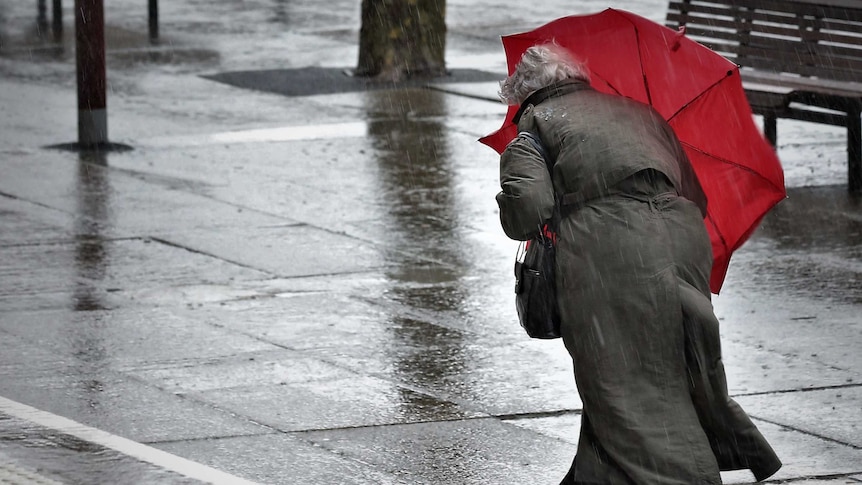
Australia’s national weather agency has issued a staunch defense of its handling of deadly flooding in New South Wales earlier this year, after a parliamentary report found it did not comprehend the scale of the threat.

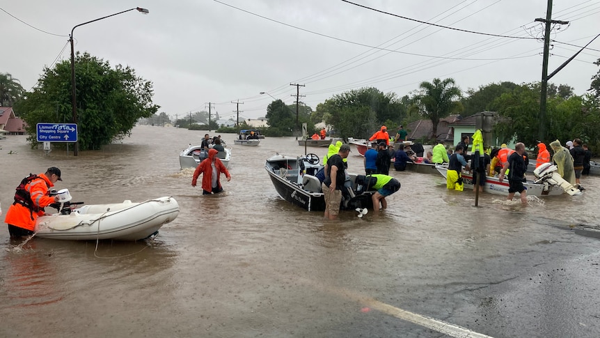
Five people died in the first flood event in the Northern Rivers on February 28, with evacuation orders for towns such as Lismore issued through the night as flood waters tore through the region.

A NSW parliamentary committee found the Bureau of Meteorology (BOM) was not prepared, that information used to make decisions was “incorrect and out of date”, and recommended it review its data processes.

The bureau declined to be interviewed by the ABC but in a statement a spokesperson said the agency “strongly refutes” the committee’s findings.

The statement outlined how the BOM warned governments, including national cabinet, and the community in 2021 of a likely La Niña event and above-average flooding risk across Australia’s north and east.

Specifically in relation to flooding in northern NSW, it said it told the State Emergency Service (SES) five days before the first event of “the potential for life-threatening flash-flooding over the NSW north coast” and that it issued flood watches and warnings “many days in advance”.

“The bureau also explicitly identified the risk for intense localized rain events, life threatening flash flooding and the potential for rapid river rises,” it said.

Aerial photo of Lismore in flood in 2017
The Northern Rivers flood event was the region’s worst on record.(ABC North Coast: Ruby Cornish)

The statement also addressed the report findings that some agencies treated it “as a nine-to-five business operation”, arguing it was instead a “365 days a year, 24/7 operation”.

The bureau said that for this event, a specialized meteorologist and a hydrologist were embedded with the SES at the Wollongong headquarters, and that the bureau supplied area-specific briefings to agencies.

It also noted that engagement with the parliamentary committee had been “limited”, and that a separate independent flood inquiry, which has handed its report to the government but was not yet public, was much more proactive with asking for information.

Space to play or pause, M to mute, left and right arrows to seek, up and down arrows for volume.

Play Video.  Duration: 1 minute 50 seconds

Probe finds lead emergency agencies failed in flood response(Bruce MacKenzie)

‘more of the same’

Kyogle Shire Council general manager Graham Kennett said the report was missing recommendations to improve telecommunications, which were crucial for monitoring levels to make decisions.

“If we know what’s going on in this catchment and in that catchment, then we have warning times and we can predict flood levels to a degree of accuracy that is good enough to make informed decisions about when people need to leave,” he said.

“It takes 45 minutes to an hour for the data to get online and in some cases that is too long for a decision-making process.”

In Lismore, a group of residents said the 37 recommendations did not go far enough, and wanted locals to be given the power to make decisions in future flood events

The parliamentary committee slammed the response of the SES during the flood crisis, accusing it of “issuing out of date, inaccurate and confusing messages”.

It has recommended that a restructure of the SES be conducted to harness local knowledge and increase the number of salaried staff and volunteers.

Man and woman sit at a long table in front of microphones
Beth Trevan (left) believes the recommendations do not afford local people enough autonomy.(ABC North Coast: Bruce MacKenzie)

Lismore Citizens Flood Review group coordinator Beth Trevan said while the inquiry findings mirrored the group’s submission, the recommendations were “disappointing” as they appeared to be “more of the same”.

Ms Trevan wants local people on the ground to have the power to make decisions.

“In the past we’ve had long term local people, who had been here for 30 or 40 years and were in senior positions at a regional level … and the knowledge of the entire area and the knowledge of all the agencies and the people who ran them was at their fingertips,” she said.

“By the time it gets transferred from here to Sydney and they have a chat with the bureau, the time is wasted, and we don’t have time.”

Catherine Cusack wearing a gray jacket and sitting in a park.
Catherine Cusack left parliament in protest of her party’s handling of the flood crisis.(abcnews)

Catherine Cusack represented the Liberal Party on the parliamentary committee, but no longer sits in parliament after letting her membership lapse in protest at her party’s handling of the crisis.

She fell short of backing the notion that local people should be making decisions but said they should be “more front and centre”.

“Of all the data that flows into them, there’s just no capacity for locals to say ‘I don’t know what it is in your gauges … but all I can tell you is the water is meters high up here in an unprecedented way’ ,” she said.

The SES said it is reviewing the report and will provide a response to parliament.

.

Categories
Australia

NSW and Victoria weather forecast predicts rain, winds and floods

The weather is expected to keep getting wetter for inland NSW and Victoria’s alpine regions today as the biggest frontal system of the season sweeps through.

The complex low pressure system is not being followed by the usual piercingly cold change, which is great news for those who are sick of shivering but a worry for the ski fields.

Why all the wild weather?

The first in a series of cold fronts moved through Western Australia on Monday, where some Perth suburbs were hit by their highest wind gusts on record and power outages caused havoc at the airport.

loading

The next swept across South Australia on Tuesday.

Today a third is sweeping across the south-east.

“That’s going to tap into some tropical moisture, leading to widespread rainfall across much of inland New South Wales and north-eastern parts of Victoria,” weather bureau meteorologist Dean Narramore said.

“The main band will really start to pick up on Thursday morning and then become widespread across New South Wales and north-eastern Victoria Thursday afternoon and Thursday night.”

He said the heaviest falls were expected west of the Great Dividing Range.

Map of Australia green over southern states indicating rainfall expected
Heavy rain is expected over the next few days.(Supplied: Bureau of Meteorology)

“This is more of an inland rain event,” Mr Narramore said.

loading

He said more than 100 millimetres of rain could fall on Victorian alpine regions today.

“That could lead to minor to moderate flooding on some of our rivers, creeks and streams,” he said.

“So something to watch as you move through later into Thursday into Friday.”

Rain is also expected to continue over northern and western parts of Tasmania, where flood warnings are also current.

Wind impacts are not expected to be as bad as in the past few days.

But Mr Narramore warned likes of about 100 kilometers an hour were still likely through north-eastern parts of Victoria, particularly for alpine areas.

He said elevated parts of New South Wales were also at risk of strong winds, with likes of up to 125 kilometers an hour predicted in the Snowy Mountains.

Watch for warnings

Victoria State Emergency Service chief officer of operations, Tim Wiebusch, urged people to keep up with emergency information.

“Ensure you listen to the advice of emergency services, and secure loose items in and around your home, park your vehicle undercover, away from trees and remain indoors until the severe weather has passed,” he said.

“As we are expecting heavy rain in parts of Victoria, it’s important you never drive through floodwater.

“Attempting to drive through flood waters may be the last decision you make,” he said.

Bad news for the snowfields

Cold fronts are usually followed by a blast of icy southerly air. But this time around temperatures have remained remarkably balmy.

.

Categories
Australia

Destructive winds, thunderstorms forecast as cold front bears down on Victoria

Strong winds and thunderstorms bringing heavy rainfall to Victoria have prompted multiple weather warnings as a cold front bears down on the state.

The front is forecast to enter the state’s west later this evening and continue traveling east through Wednesday, bringing showers, thunderstorms and powerful north-westerly winds.

The State Emergency Service (SES) said the weather system “could be the most significant cold front of the winter” and urged residents to prepare early and remain wary of the risk falling trees posed.

Watch and Act alerts warning residents to prepare and take shelter indoors have been issued for areas including Central Highlands, Dandenong and the Great Dividing Range, as well as the Grampians in the state’s west.

Severe weather warnings of destructive winds have been issued for the Central, South West and North Central districts, and for parts of the East Gippsland, North East, West, South Gippsland and Wimmera districts.

The Bureau of Meteorology has forecast winds averaging 65 kilometers per hour, with likes of up to 100 kph in some elevated areas.

Winds described as “locally destructive” reaching up to 130 kph are predicted over Alpine peaks from early Wednesday morning.

Possible flooding in state’s north-east

Senior meteorologist Kevin Parkin said the wind was of most concern.

“When we talk about wind likes 90 to 100 kph, that’s capable of breaking branches off trees and also capable of pushing over weakened trees as well,” he said.

He said the peak of the tastes was expected to move through Melbourne between midnight and 4am.

“For many people through central parts, when you wake up on Wednesday morning, be wary of widespread vegetation that may have been stripped from trees across roads,” Mr Parkin said.

“From sunrise onwards, the risk really is in the eastern part of the state and it will continue there for much of the day.”

There are concerns heavy rain could cause flooding in some north-east Victorian catchments.

Mr Parkin said it was going to be a “windy week” and severe weather warnings would likely continue cropping up until a change forecast to move into the state from the south this weekend.

SES chief officer of operations, Tim Wiebusch, urged Victorians to tune into messages from emergency services over the next 24 hours to 48 hours.

He said motorists on the road tonight should be extra vigilant about the risk of debris such as fallen trees, branches and powerlines.

“We can’t stress enough that if you do come across floodwaters, do not attempt to drive through floodwaters,” he said.

“It may be the last decision you make.”

Mr Wiebusch said people should prepare for localized power and internet outages and secure loose items around their homes, such as outdoor furniture and trampolines.

Meanwhile WorkSafe issued a reminder for managers to ensure workplaces are prepared for the wild weather.

“Strong winds can turn unsecured objects into dangerous projectiles, including partly completed structures, roof sheets, scaffold plans, temporary fencing, and unsecured tools,” health and safety executive director Narelle Beer said.

“Loose objects must be removed or suitably secured so that they don’t blow away and become a danger to workers and the general public.”

.