bureau of meteorology – Michmutters
Categories
Australia

BOM warns wet spring and summer could see more Queensland floods

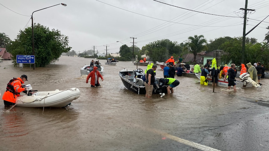
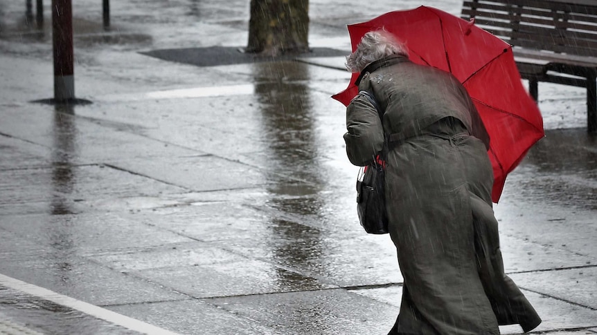
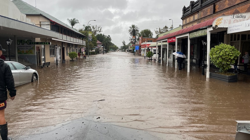
Queenslanders are being warned to expect spring and summer conditions similar to the La Niña event that brought widespread flooding to parts of the state in February.

The Bureau of Meteorology (BOM) today briefed cabinet on the seasonal conditions ahead.

Premier Annastacia Palaszczuk said it was likely the state would see a mild bushfire season but above average rainfall was set to continue.

“The good news is we’re not expecting a big bushfire season, but we are expecting a wetter than normal spring,” she said.

“These conditions could be similar to the conditions over the summer of this year.”

Ms Palaszczuk said the government would ensure councils across the state were prepared for more wet weather and were implementing recommendations from the last flooding event.

‘Remove a bit of flooding’ expected

BOM meteorologist Laura Boekel said the outlook applied to the whole state, and could not be pinpointed more specifically.

“All of Queensland should be aware that we are expecting an increased chance of above average rainfall this season,” she said.

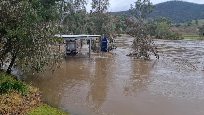
“If we couple what we have seen in the winter, which is a lot more moisture and grounds remaining wet and not drying up, with the forecast of an above average season, that means we could see quite a bit of flooding across Queensland.

“All of Queensland should be across the fact that we are expecting to see quite a bit of rainfall.”

A controlled fire is burning next to green grass trees with a vehicle in the background
Queenslanders living in regional areas should expect “significant grassfire activity” over spring and summer months.(Supplied: Lydall Scobell)

‘Significant grass fire activity’

Queensland Fire and Emergency Services Commissioner Greg Leach said while the bushfire season is expected to be normal, those in regional parts of the state need to be prepared for grassfire.

“Our modeling still shows that we’re likely to experience a normal bushfire season,” he said.

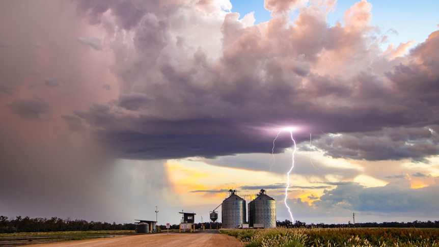
“While we’re unlikely to see the extensive bushfires such as we saw in 2018/19, we are going to see significant grassfire activity in some parts of the state.

“The recent rain we’ve had has brought on a significant amount of grass load growth through western, central and southern parts of Queensland, and the frosts that we’ve seen in recent weeks has dried off much of that vegetation.”

He said rural brigades had mobilized to complete 133 hazard reduction burns totaling nearly 60,000 hectares.

Emergency Services Minister Mark Ryan urged those in regional Queensland to be prepared for grassfires.

“For people in the north, and central and west, there is still a significant chance for you to experience grassfire… you need to be prepared for that season.”

Flood cameras and sirens to be installed across Ipswich

Ipswich City Council Mayor Teresa Harding said her council was conducting its own flood review which will begin at the end of this month.

“It’s obviously quite emotional to hear of this [outlook],” she said.

.

Categories
Australia

Bureau of Meterology rejects suggestions it was unprepared for Northern Rivers NSW flood event

Australia’s national weather agency has issued a staunch defense of its handling of deadly flooding in New South Wales earlier this year, after a parliamentary report found it did not comprehend the scale of the threat.

Five people died in the first flood event in the Northern Rivers on February 28, with evacuation orders for towns such as Lismore issued through the night as flood waters tore through the region.

A NSW parliamentary committee found the Bureau of Meteorology (BOM) was not prepared, that information used to make decisions was “incorrect and out of date”, and recommended it review its data processes.

The bureau declined to be interviewed by the ABC but in a statement a spokesperson said the agency “strongly refutes” the committee’s findings.

The statement outlined how the BOM warned governments, including national cabinet, and the community in 2021 of a likely La Niña event and above-average flooding risk across Australia’s north and east.

Specifically in relation to flooding in northern NSW, it said it told the State Emergency Service (SES) five days before the first event of “the potential for life-threatening flash-flooding over the NSW north coast” and that it issued flood watches and warnings “many days in advance”.

“The bureau also explicitly identified the risk for intense localized rain events, life threatening flash flooding and the potential for rapid river rises,” it said.

Aerial photo of Lismore in flood in 2017
The Northern Rivers flood event was the region’s worst on record.(ABC North Coast: Ruby Cornish)

The statement also addressed the report findings that some agencies treated it “as a nine-to-five business operation”, arguing it was instead a “365 days a year, 24/7 operation”.

The bureau said that for this event, a specialized meteorologist and a hydrologist were embedded with the SES at the Wollongong headquarters, and that the bureau supplied area-specific briefings to agencies.

It also noted that engagement with the parliamentary committee had been “limited”, and that a separate independent flood inquiry, which has handed its report to the government but was not yet public, was much more proactive with asking for information.

Space to play or pause, M to mute, left and right arrows to seek, up and down arrows for volume.

Play Video.  Duration: 1 minute 50 seconds

Probe finds lead emergency agencies failed in flood response(Bruce MacKenzie)

‘more of the same’

Kyogle Shire Council general manager Graham Kennett said the report was missing recommendations to improve telecommunications, which were crucial for monitoring levels to make decisions.

“If we know what’s going on in this catchment and in that catchment, then we have warning times and we can predict flood levels to a degree of accuracy that is good enough to make informed decisions about when people need to leave,” he said.

“It takes 45 minutes to an hour for the data to get online and in some cases that is too long for a decision-making process.”

In Lismore, a group of residents said the 37 recommendations did not go far enough, and wanted locals to be given the power to make decisions in future flood events

The parliamentary committee slammed the response of the SES during the flood crisis, accusing it of “issuing out of date, inaccurate and confusing messages”.

It has recommended that a restructure of the SES be conducted to harness local knowledge and increase the number of salaried staff and volunteers.

Man and woman sit at a long table in front of microphones
Beth Trevan (left) believes the recommendations do not afford local people enough autonomy.(ABC North Coast: Bruce MacKenzie)

Lismore Citizens Flood Review group coordinator Beth Trevan said while the inquiry findings mirrored the group’s submission, the recommendations were “disappointing” as they appeared to be “more of the same”.

Ms Trevan wants local people on the ground to have the power to make decisions.

“In the past we’ve had long term local people, who had been here for 30 or 40 years and were in senior positions at a regional level … and the knowledge of the entire area and the knowledge of all the agencies and the people who ran them was at their fingertips,” she said.

“By the time it gets transferred from here to Sydney and they have a chat with the bureau, the time is wasted, and we don’t have time.”

Catherine Cusack wearing a gray jacket and sitting in a park.
Catherine Cusack left parliament in protest of her party’s handling of the flood crisis.(abcnews)

Catherine Cusack represented the Liberal Party on the parliamentary committee, but no longer sits in parliament after letting her membership lapse in protest at her party’s handling of the crisis.

She fell short of backing the notion that local people should be making decisions but said they should be “more front and centre”.

“Of all the data that flows into them, there’s just no capacity for locals to say ‘I don’t know what it is in your gauges … but all I can tell you is the water is meters high up here in an unprecedented way’ ,” she said.

The SES said it is reviewing the report and will provide a response to parliament.

.

Categories
Australia

Australian weather: States brace for cold snap, rain and major flood warnings

Australians are bracing for a nationwide cold snap as some parts of the country battle temperatures below zero, rain, hail and flood warnings.

The Bureau of Meteorology told NCA NewsWire that Queensland’s August average so far this year had fallen between four and eight degrees since the same time period in 2021, plummeting to -2C temperatures in some parts of the state.

“It started off a lot warmer last year than it did this year,” meteorologist Livio Regano said.

The Darling Downs and Granite Belt regions were the coldest parts of the state, falling to -2C on Monday morning as a cold, dry air mass pushed north from South East Queensland.

A 1800km blanket of frost is also expected to hit Queensland, stretching between Stanthorpe and the far north.

The cold snap sweeping the nation has torn through NSW, ACT, Victoria, South Australia and Tasmania, bringing fog, rain and snow to some regions.

Widespread fog blanketed five states on Monday, triggering a weather warning for SA motorists.

The road weather alert was issued early on Monday, saying there would be reduced visibility and potentially dangerous driving conditions in Adelaide and the Adelaide Hills.

In Victoria, meteorologist Dean Narramore said temperatures in Westmere, in the state’s southwest, nosedived to -1.4C, while other regions were hit with zero degrees.

“The high pressure system has moved in from late last week, which is giving Victoria in particular those cold mornings,” he said.

NSW and the ACT are bracing for snow over their southern ranges, with a chance of thunderstorms on the slopes later this week.

There’s a flood warning in the southern NSW town of Gundagai following the highest recorded overflow from the Yass River into the Burrinjuck Dam.

Water releases from the dam increased to 98,000 megalitres a day over the weekend following heavy rain in parts of the region.

Down south, Tasmanian residents are feeling colder than forecast temperatures due to the cold northwesterly winds hitting the state.

Hobart sat at 1.5 degrees on Monday morning, although the temperature feels-like dropped to -4C.

Alongside Adelaide, the state has also issued road weather warnings and urged motorists to drive to the conditions following thick fog.

The east coast of Tasmania could also experience minor flooding over the weekend, with a Tasman low likely to form and bring heavy rain.

Residents living in Queensland, NSW, ACT, Victoria, SA and Tasmania are expected to experience milder mornings after Wednesday.

.

Categories
Australia

North-east Victoria braces for wet spring after week of rainy weather

Residents of north-east of Victoria are keeping a close eye on predictions of a wet spring.

The Bureau of Meteorology recently said a wetter August to October was likely for most of the country, including more than double the normal chance of unusually high rainfall for most areas in the eastern-two thirds of the mainland.

North-east Victoria has already recorded good rainfall, hail, as well as a number of flood alerts and minor flood events just a week into August.

Walwa Riverside Caravan Park owner and manager Heidi Conway said the Murray River had peaked about five meters at the park late on Friday and into Saturday morning.

“The Murray River broke the bank and came into our park so we’ve probably got a quarter of the park underwater at the moment,” she said.

“Our cabins are elevated up so it hasn’t affected those at all, but it looks like it’s going down now.”

‘You can’t stop nature’

Ms Conway said her business was not feeling too many impacts from the latest flooding event given it was quiet over winter.

She said Saturday’s flooding was similar to the last flooding event they saw at the park in September 2021

She said the latest event had arrived earlier than usual.

A flooded area with several trees around and a bench half submerged in water
Ms Conway says it’s not great to have to deal with flooding concerns.(Supplied: Heidi Conway)

“Normally we would look at maybe flooding towards September but due to seasonal changes we’ve copped it now as well,” she said.

“We have heard that we will have a wet year so that will impact the amount of people that we have in the park.

“After COVID and everything it’s not a great thing to happen but you can’t stop nature so we just have to look to all the things that we can do to deal with that.”

Ms Conway said despite the latest weather challenges she still expected to have a busy period leading up to, and during, Christmas.

Eyes on the sky

Victoria State Emergency Service north-east duty officer Dan Walton said the heaviest of the weekend’s rain had come and gone.

He said his organization was expecting steadier conditions early next week.

But he said it was important for community members to remain vigilant to any weather changes.

“This is not going to go away.” he said.

“We’re going to have the next several months of wet, warmer than average temperatures, more than average rainfall.

“This is going to continue until probably, at least, through November.”

.

Categories
Australia

Southern Queensland weather forecast for another wet spring

Authorities and farmers in Queensland are preparing for a wet spring after a “nightmare” winter of rain and flooding.

The Bureau of Metrology this week declared the Indian Ocean Dipole was “negative”, which typically meant wetter than normal weather over winter and spring for much of southern and eastern Australia.

The bureau said there was also a chance La Nina could re-form for a third time during spring.

Condamine farmer Jake Hamilton said he was slightly concerned about the forecast after an “absolute nightmare” winter of muddy paddocks at his southern Queensland property.

Mr Hamilton said he had received more than 150 millimeters of rain in May, which severely delayed the planting of crops.

“We’ve had a 75-tonne snatch strap tied to the front of our planting tractor for the last three months, and it has certainly got a lot of use,” Mr Hamilton said.

“We’ve been bogging machines left, right and centre, whether it’s tractors or sprayers, just trying to get through the mud.

“I don’t think anyone in our area is going to want to go through a harvest that was as wet as the planting that we just had.”

A tractor in a muddy paddock
Tractors have been getting bogged down in wet paddocks. (Supplied: Jake Hamilton)

Mr Hamilton said the season overall had been as good as farmers could have hoped for.

But he said if the forecast for a wet spring did eventuate, it could exacerbate problems with plant diseases.

He said combined with a shortage of fungicides, it could result in significant crop losses.

“But at the end of the day, it is just a forecast,” Mr Hamilton said.

“We’ve had La Nina years where we’ve had little to no rain, so we can only just keep an eye on the short range and see what happens.

“But at least we are sort of preparing for it to be quite wet.”

A man with a beard standing in front of some crops
Jake Hamilton says he’s slightly concerned about forecasts of a wet spring.(Supplied: Jake Hamilton)

Authorities get ready

Authorities have also started preparations for a wet spring, with flooding in Queensland this year having already claimed more than 20 lives.

Dam operator Sunwater said 11 of its 19 reservoirs across Queensland were either at or close to capacity.

A lot of water rushes over a dam spillway
Leslie Dam at Warwick is one of the 11 dams at full capacity.(Supplied: Chris McFerran)

Sunwater executive general manager of operations, Colin Bendall, said communities needed to be vigilant if more early spring or summer rain was coming.

“Some of the preparation we’ve been doing is we conduct exercises with the local disaster management groups, and the Bureau of Meteorology,” Mr Bendall said.

He said staff were also being trained in the use of emergency action plans in the event of any further spills from dams.

loading

wet-summer

University of Southern Queensland climatologist Chelsea Jarvis said there was between a 65 to 80 per cent chance regions such as the Darling Downs would exceed their median rainfall.

She said scientists would continue to monitor the situation to see whether the Indian Ocean Dipole strengthened towards the end of the year.

“The end of this Indian Ocean Dipole event, whether it be October or December, can also determine how the likelihood of rain going into summer,” Ms Jarvis said.

“The second thing I’d be looking out for is what’s going on in the Pacific Ocean with this La Nina event, it’s just sort of hanging out there.”

.

Categories
Australia

NSW and Victoria weather forecast predicts rain, winds and floods

The weather is expected to keep getting wetter for inland NSW and Victoria’s alpine regions today as the biggest frontal system of the season sweeps through.

The complex low pressure system is not being followed by the usual piercingly cold change, which is great news for those who are sick of shivering but a worry for the ski fields.

Why all the wild weather?

The first in a series of cold fronts moved through Western Australia on Monday, where some Perth suburbs were hit by their highest wind gusts on record and power outages caused havoc at the airport.

loading

The next swept across South Australia on Tuesday.

Today a third is sweeping across the south-east.

“That’s going to tap into some tropical moisture, leading to widespread rainfall across much of inland New South Wales and north-eastern parts of Victoria,” weather bureau meteorologist Dean Narramore said.

“The main band will really start to pick up on Thursday morning and then become widespread across New South Wales and north-eastern Victoria Thursday afternoon and Thursday night.”

He said the heaviest falls were expected west of the Great Dividing Range.

Map of Australia green over southern states indicating rainfall expected
Heavy rain is expected over the next few days.(Supplied: Bureau of Meteorology)

“This is more of an inland rain event,” Mr Narramore said.

loading

He said more than 100 millimetres of rain could fall on Victorian alpine regions today.

“That could lead to minor to moderate flooding on some of our rivers, creeks and streams,” he said.

“So something to watch as you move through later into Thursday into Friday.”

Rain is also expected to continue over northern and western parts of Tasmania, where flood warnings are also current.

Wind impacts are not expected to be as bad as in the past few days.

But Mr Narramore warned likes of about 100 kilometers an hour were still likely through north-eastern parts of Victoria, particularly for alpine areas.

He said elevated parts of New South Wales were also at risk of strong winds, with likes of up to 125 kilometers an hour predicted in the Snowy Mountains.

Watch for warnings

Victoria State Emergency Service chief officer of operations, Tim Wiebusch, urged people to keep up with emergency information.

“Ensure you listen to the advice of emergency services, and secure loose items in and around your home, park your vehicle undercover, away from trees and remain indoors until the severe weather has passed,” he said.

“As we are expecting heavy rain in parts of Victoria, it’s important you never drive through floodwater.

“Attempting to drive through flood waters may be the last decision you make,” he said.

Bad news for the snowfields

Cold fronts are usually followed by a blast of icy southerly air. But this time around temperatures have remained remarkably balmy.

.

Categories
Australia

Destructive winds, thunderstorms forecast as cold front bears down on Victoria

Strong winds and thunderstorms bringing heavy rainfall to Victoria have prompted multiple weather warnings as a cold front bears down on the state.

The front is forecast to enter the state’s west later this evening and continue traveling east through Wednesday, bringing showers, thunderstorms and powerful north-westerly winds.

The State Emergency Service (SES) said the weather system “could be the most significant cold front of the winter” and urged residents to prepare early and remain wary of the risk falling trees posed.

Watch and Act alerts warning residents to prepare and take shelter indoors have been issued for areas including Central Highlands, Dandenong and the Great Dividing Range, as well as the Grampians in the state’s west.

Severe weather warnings of destructive winds have been issued for the Central, South West and North Central districts, and for parts of the East Gippsland, North East, West, South Gippsland and Wimmera districts.

The Bureau of Meteorology has forecast winds averaging 65 kilometers per hour, with likes of up to 100 kph in some elevated areas.

Winds described as “locally destructive” reaching up to 130 kph are predicted over Alpine peaks from early Wednesday morning.

Possible flooding in state’s north-east

Senior meteorologist Kevin Parkin said the wind was of most concern.

“When we talk about wind likes 90 to 100 kph, that’s capable of breaking branches off trees and also capable of pushing over weakened trees as well,” he said.

He said the peak of the tastes was expected to move through Melbourne between midnight and 4am.

“For many people through central parts, when you wake up on Wednesday morning, be wary of widespread vegetation that may have been stripped from trees across roads,” Mr Parkin said.

“From sunrise onwards, the risk really is in the eastern part of the state and it will continue there for much of the day.”

There are concerns heavy rain could cause flooding in some north-east Victorian catchments.

Mr Parkin said it was going to be a “windy week” and severe weather warnings would likely continue cropping up until a change forecast to move into the state from the south this weekend.

SES chief officer of operations, Tim Wiebusch, urged Victorians to tune into messages from emergency services over the next 24 hours to 48 hours.

He said motorists on the road tonight should be extra vigilant about the risk of debris such as fallen trees, branches and powerlines.

“We can’t stress enough that if you do come across floodwaters, do not attempt to drive through floodwaters,” he said.

“It may be the last decision you make.”

Mr Wiebusch said people should prepare for localized power and internet outages and secure loose items around their homes, such as outdoor furniture and trampolines.

Meanwhile WorkSafe issued a reminder for managers to ensure workplaces are prepared for the wild weather.

“Strong winds can turn unsecured objects into dangerous projectiles, including partly completed structures, roof sheets, scaffold plans, temporary fencing, and unsecured tools,” health and safety executive director Narelle Beer said.

“Loose objects must be removed or suitably secured so that they don’t blow away and become a danger to workers and the general public.”

.