Brisbane Lord Mayor Adrian Schrinner will release further details on Tuesday but the research and proposals have already been discussed by civic cabinet and development along the corridor has been ruled out.
loading
The extensive documentation, including a business case, has also been provided to Infrastructure Australia and the Queensland government.
While Schrinner has yet to comment on the research, or proposals, he announced more Brisbane Metro vehicles on Monday and said: “I am now more confident than ever that we can look towards expanding the Metro network to other areas of our city.”
Former Labor state governments had planned extra bus lanes for the corridor and possible western bypass tunnels under the original Western Brisbane Transport Network strategy in 2009.
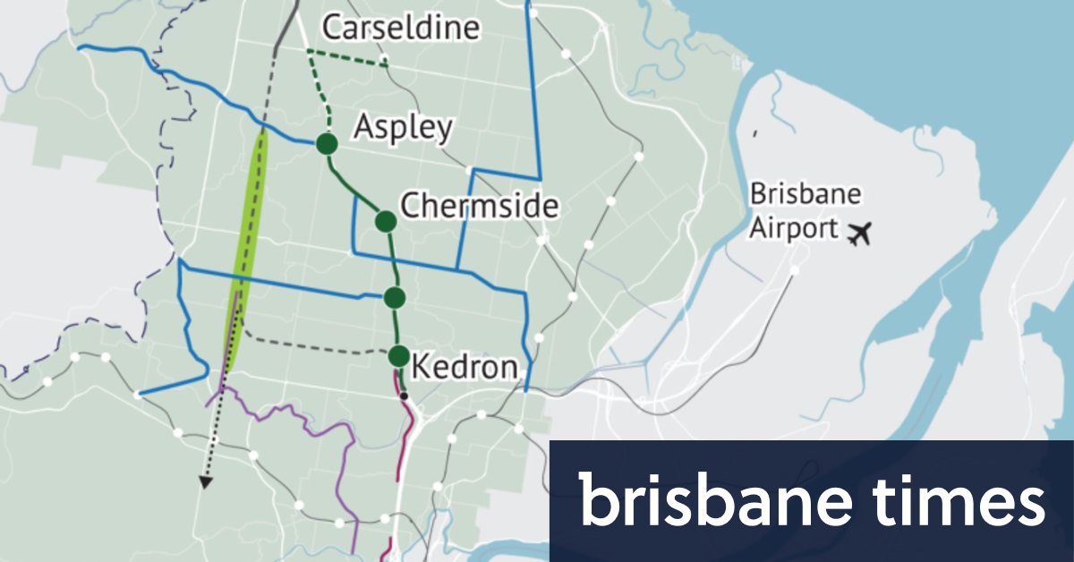
The latest research also flagged another possible tunnel south from Everton Park to Toowong, similar to one examined by a former Labor state government. It would link up with the Western Freeway and Legacy Way.

Brisbane’s CBD from the lookout on top of the Chermside Hill Reserve.Credit:Tony Moore
Brisbane City Council infrastructure committee chair Andrew Wines said escalating congestion costs and environmental issues meant there was no option but to go underground.
“This study shows the economic cost of north Brisbane’s congestion will be a staggering $1.5 million a day within a decade, which is totally unacceptable,” Wines told BrisbaneTimes.
“Brisbane is the fastest-growing capital city in the country and our northern neighbors in Moreton Bay – who are investigating options for alternatives to the Bruce Highway – are also growing quickly.
“This study must start a conversation between all levels of government – and the private sector – about options to ensure northside commuters get home sooner and safer.”
The preserved corridor between Gympie Road at Carseldine and Shand Street at Alderley was identified in the 1980s and has remained largely free of houses since then.
However, the research found many threatened and endangered species in parks along the original Trouts Road route from Stafford to Carseldine: the large Chermside Hills Reserve, the Downfall Creek Bush Reserve, Mine Hill Reserve and Sparkes Hill Reserve at Alderley.
Environmental issues identified in Chermside Hills Reserves and linked parks
Flora
- Chermside Hills Reserve is considered a high-risk trigger area.
- There are approximately 21 threatened plant species recorded within the vicinity of the corridor.
- This includes endangered eucalypt woodland and open forest community
- It is significant conservation value, only found in the Chermside Hills Reserve area. The ecosystem cannot be offset in another location.
Fauna
- The identified threatened and vulnerable species are powerful owls, gray headed flying foxes and tusked frogs, in addition to sugar and squirrel gliders.
- Koalas are regularly spotted in the Chermside Hills Reserve. Evidence of their presence was detected during environmental investigations undertaken as part of the development of the business case.
cultural heritage
- The study found it has a “rich Aboriginal peoples’ history”.
- Examples include artefact scatters, marked trees, earthen features, pathways, stone arrangements, story places and campsites.
- “A future detailed business case will be important to confirm the presence of Aboriginal cultural heritage values in the study area and strategies to manage potential impacts.”
Those environmental concerns rule out the original plan – first considered in the 1960s – to transform Trouts Road into a four-lane highway between Alderley and Carseldine.
Community concern over the prospect of a highway running between bushland and housing estates, and altering local traffic flows, had seen the future of the corridor debated in recent federal, state and council election campaigns.

Looking towards Brisbane CBD down Old Northern Road from Everton Hills.Credit:Tony Moore
The research shows the proposed underground motorway would reduce traffic on Transurban’s existing Airport Link and Legacy Way toll tunnels by between 11 and 31 per cent by 2041.
However, it reduces traffic on major northside arterial roads; including Gympie Road (35 per cent less traffic by 2041) and Wardell Street (down 23 per cent by 2041).
The long-term plan is to increase bus lanes on those arterial roads.
The RACQ’s 2021 congestion report released in February 2022 shows Stafford, Old Northern, South Pine, Rode and Hamilton roads slowing to mid 30km/h during peak periods, adding minutes to trips.