Excessive rainfall continued to plague parts of the Lower 48 on Monday morning, with counties west and south of Chicago under flash flood warnings after seeing up to half a foot of rain.
Every deluge is operating in a warmer atmosphere because of human-caused climate change and is capable of unleashing more extreme amounts.
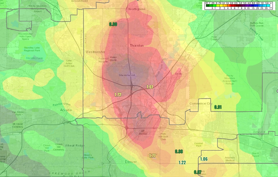
In Denver, thunderstorms blasted parts of the northern metro area on Sunday evening, drenching them with up to an inch and a half of rain in just 20 minutes. In some areas, rainfall of this intensity is only expected to occur every several hundred years.
Numerous roads were closed, including a section of Interstate 70. Denver’s ABC affiliate described a “traffic nightmare” with drivers stranded for hours along the interstate and nearly 20 people needing rescue.
“Looks like our heaviest report came in at 2.5 inches of rain,” said David Barjenburch, a meteorologist at the National Weather Service office in Boulder, although radar showed the possibility of locally higher amounts.
The dark green area in this map represents where 2″+ of rain likely fell in <30 minutes yesterday.
This includes Globeville, City Park, Clayton, Elyria-Swansea, Park Hill + Commerce City.#9wx #COwx pic.twitter.com/fkvXyFqAss
— Chris Bianchi (@BianchiWeather) August 8, 2022
I have explained that most areas only had storms for about 40 minutes at any given location. They were moving at about 15 mph.
“This is the peak [time of year] in terms of monsoonal rainfall,” said Barjenburch, referring to the Southwest monsoon — a seasonal wind shift that helps moisture to drift north over the desert Southwest, Four Corners region and, at times, the Colorado Front Range. “July, early August is typically our flash flood season. And this time we had abundant moisture, a lot more than we typically have here.”
He referred to infamous flood events, like one that struck Fort Collins in 1997 or the Big Thompson episode, which killed 144 people when a foot of rainfall gushed into the Big Thompson River in just a few hours’ time on July 31, 1976.
The people stranded in Friday’s Death Valley deluge were able to “carefully travel out through damaged roadways” over the weekend, according to the National Park Service.
About 1.46 inches of rain came down — just shy of the 1.47-inch record. The total equates to about three-quarters of a typical year’s worth of rain.
The lowest, driest and hottest location in the United States, Death Valley averages just 0.11 inches of rain in August.
Many cars were damaged by the sudden torrent and resulting mudslides.
The Park Service reported that the flooding destroyed a water system that serves numerous park residences and facilities. It also said that many thousands of roads were damaged and littered with debris.
Like Denver, its downpours were triggered by the Southwest monsoon.
Flooding in northern Illinois
Parts of Illinois west and south of Chicago were also visited by heavy rain early Monday, which sparked flash flood warnings in northwestern and north central parts of the state. The Weather Service office serving Chicago had received about a dozen reports of flooding, including around Rockford through midday.
“[T]he significant flash flooding has gotten as close to the metro as Rockford and Byron, Illinois, about 90 miles west of Chicago,” said Matt Friedlein, a meteorologist at the Weather Service. “DeKalb and Sycamore… about 70 miles west of Chicago… saw some flooding too.”
Friedlin said Rockford broke its Aug. 8 rainfall record with 2.62 inches as of 7 am One weather station south of Rockford posted 6.21 inches.
Some historical perspective on the rainfall the past 2 days in #Rockford: The consecutive calendar days (8/7/2022 to 8/8/2022) of 2″+ rainfall totals is the first such occurrence there since July 23-24, 2010. 4.70″ fell on 7/23/2010 and 2.81″ fell on 7/24/2010. #ilwx
— NWS Chicago (@NWSChicago) August 8, 2022
A brief slug of heavy rain passed through Chicago, but its impacts were limited.
Explaining the exceptional rainfall
The heavy rainfall has been driven by characteristic summertime moisture pooling along a stalled front draped from the Colorado Rockies into central states sitting atop a heat dome sprawled over the Southern US Such fronts wring the humidity out of the air like someone squeezing out a washcloth. That can lead to rainfall rates of 2 to 3 inches — or more — per hour. These fronts also act like train tracks guiding developing thunderstorms over the same areas repeatedly.
That was the case eight days ago in St. Louis, where 7.87 inches of rain fell in six hours’ time. That prompted flash flood emergencies across the city, and cars inundated by rising floodwaters. Extreme flooding plagued eastern Kentucky just two days later, with 37 people now confirmed dead. President Biden, who visited the region on Monday, has pledged assistance from the federal government in recovery efforts. Another storm dropped up to 14 inches of rain late last week near Effingham, Ill.
As the atmosphere continues to warm, events of this magnitude will become increasingly common. That will translate to increased economic losses, damage to vulnerable and aging infrastructure, and danger to the public, particularly in urban areas.
In the past two weeks, we’ve observed four 1-in-1,000 year rain events. That doesn’t mean that level of rainfall occurs once every thousand years, but rather that in any given year it should have a 0.1 percent chance of occurring.
A limitation of the 1,000-year rainfall metric is that it is based on historical data and on the assumption the climate isn’t changing. As the atmosphere continues to warm, and its capacity to store and transport moisture increases, this metric loses its meaning as previously rare events become more common.