Tornado warning expires

Updated: 8:45 PM EDT Aug 1, 2022
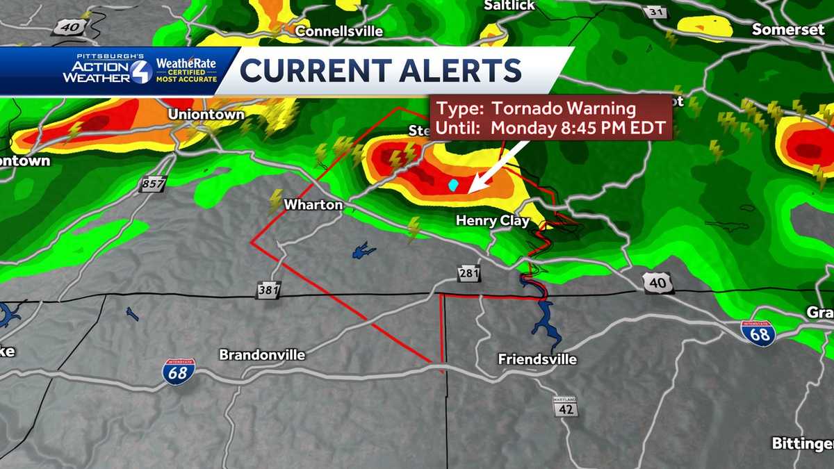
UPDATE: The tornado warning has now expired. PREVIOUS: The National Weather Service in Pittsburgh has issued a tornado warning for southeastern Fayette County until 8:45 pm Monday. The earlier warnings for Greene and Washington counties have expired. Live updates from Pittsburgh’s Action Weather in the video player above. At 8:27 pm, a severe thunderstorm capable of producing a tornado was located near Farmington, or 16 miles southeast of Uniontown, moving southeast at 20 mph.More: Read the alert for your countyInteractive radar: Track storms as they move through your areaLearn how to enable automatic weather alerts on the WTAE mobile appHAZARD…Tornado.SOURCE…Radar indicated rotation.IMPACT.. .Flying debris will be dangerous to those caught without shelter. Mobile homes will be damaged or destroyed. Damage to roofs, windows, and vehicles will occur. Tree damage is likely.Locations impacted include… Markleysburg.TORNADO…RADAR INDICATEDMAX HAIL SIZE…<.75 INInstructions: TAKE COVER NOW! Move to a basement or an interior room on the lowest floor of a sturdy building. Avoid windows. If you are outdoors, in a mobile home, or in a vehicle, move to the closest substantial shelter and protect yourself from flying debris. Download the WTAE app to stay connected with severe weather alerts and breaking news. Always have the WTAE mobile app? Click here to learn how to get automatic severe weather alerts for where you live.
UPDATE: The tornado warning has now expired.
PREVIOUS: The National Weather Service in Pittsburgh has issued a tornado warning for southeastern Fayette County until 8:45 pm Monday. The earlier warnings for Greene and Washington counties have expired.
Live updates from Pittsburgh’s Action Weather in the video player above.
At 8:27 pm, a severe thunderstorm capable of producing a tornado was located near Farmington, or 16 miles southeast of Uniontown, moving southeast at 20 mph.
HAZARD…Tornado.
SOURCE…Radar indicated rotation.
IMPACT…Flying debris will be dangerous to those caught without shelter. Mobile homes will be damaged or destroyed. Damage to roofs, windows, and vehicles will occur. Tree damage is likely.
Locations impacted include… Markleysburg.
TORNADO…RADAR INDICATED
MAX HAIL SIZE…<.75 IN
Instructions: TAKE COVER NOW! Move to a basement or an interior room on the lowest floor of a sturdy building. Avoid windows. If you are outdoors, in a mobile home, or in a vehicle, move to the closest substantial shelter and protect yourself from flying debris.
- Download the WTAE app to stay connected with severe weather alerts and breaking news.
- Already have the WTAE mobile app? Click here to learn how to get automatic severe weather alerts for where you live.