CNN
—
Two rounds of excessive heat will grip a large part of the country this week, impacting people from the Plains to the Midwest and the Northeast.
Heat advisories are in place for more than 30 million people from Oklahoma and Arkansas to Minnesota.
“Daytime highs will likely reach into the upper 90s to low 100s, and heat indices perhaps reaching 110 degrees when combined with high dewpoints,” the Weather Prediction Center said in its morning discussion Tuesday.
This heat will spread eastward, impacting the Northeast by the end of the week, then another round of heat will hit the Plains once again.
Between the waves of above-average heat, a bit of relief will come as cooler air pushes through.
Here is when to expect the heat and the minor relief.
“Dangerous heat indices expected today across much of central and southern (Minnesota) with afternoon heat index values expected to top out around 105 degrees,” warned the National Weather Service office in the Twin Cities in Minnesota.
Heat index values – the temperature it feels like when heat is combined with humidity – are for shady locations, the weather service explained. “If you are exposed to direct sunlight, the heat index value can be increased by up to 15 (degrees).”
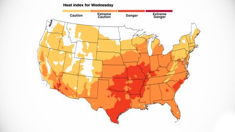
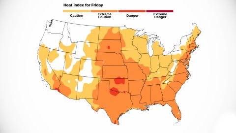
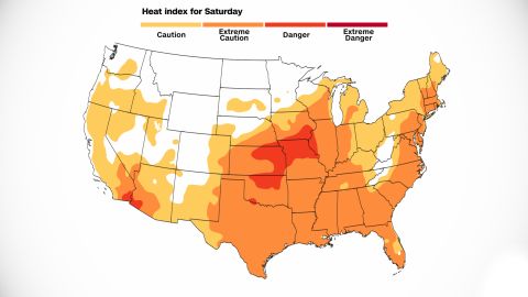
The weather service breaks down the heat index temperatures into four different risk levels based on how heat index temperatures could affect the body. Danger, the third of four categories, is for forecast heat indices reaching 103 to 124 degrees. At this level, heat cramps or heat exhaustion is likely, and heatstroke is possible with prolonged exposure and/or physical activity. The maps below show the forecast dangers (dark orange) this week.
The heat will be felt much farther and wider than in Minnesota.

An area of high pressure sitting over the Great Lakes is creating bright sunshine. But it’s also resulting in warm, moist air from the south to spill into the region.
Plainly put: High pressure is making it hot.
It is generating above-normal temperatures for such a large area in the midsection of the country. “Today looks to be the hottest day of the week,” said the weather service office in Wichita, Kansas.
Here, temperatures will also top out around 100 degrees. But once you factor in the humidity, it will feel closer to 105 degrees in some areas.
In southern Nebraska, it will feel even hotter.
“Heat index values are now forecast to climb as high as 110 degrees in eastern portions of the area,” said the weather service office in Hastings.
There may be one saving grace – a nice breeze.
“The good news is that south winds of 10-15 mph with gusts up to 25 mph will help combat the oppressive heat,” the weather service said.
The heat will even affect Kentucky, where the horrific flooding happened less than a week ago.

High temperatures are expected to climb into the lower 90s Wednesday and Thursday, proving challenging for those still living without power from the floods.
The heat will march on to the Northeast by the end of the week, giving the region a small window to cool down.

For Washington, DC, and New York, the extreme heat will peak on Thursday and Friday. The weather service office in Washington mentioned in its morning discussion the forecast models favor “highs in the mid-90s which carries heat indices into the 100 to 104 degree range.”
New York City could even feel like 100 on Thursday and Friday, not able to escape the sweltering heat.
Its weather service office warned a heat advisory could be issued for those days.
By Saturday, a cold front will swing through the Northeast, bringing the potential for heavy rainfall and a temporary improvement in temperatures.

After a brief reprieve, another round of heat will quickly hit the same areas as the first, sending high temperatures soaring once again.
“Friday looks to be the next chance of widespread 90s across central/southern Minnesota,” said the weather service office in the Twin Cities.
While this round may not last quite as long as the first, the heat will be just as potent.
“The center of the upper ridge looks to be situated over Kansas during the weekend ensuring the return of triple-digit heat to many areas,” the weather service said.

By Saturday, another cold front will move through the area, helping to drop temperatures out of the triple-digit range and return them to more seasonal norms.
Saturday’s highs – back in the low 80s for Minneapolis – sound almost refreshing compared to heat indices in the triple digits.
While the Midwest starts to cool off, the second wave of heat will push into the Northeast by the beginning of next week.
“This wave looks to reach the Northeast by Sunday with another brief wave of high temperatures expected to continue ahead of a cold front into Monday,” the Weather Prediction Center said Tuesday.
.
