There will be no escape from the heat in Texas, which has already endured a historically hot summer. Temperatures there are projected to remain above normal — with highs mostly in the triple digits — for the whole week.
The heat wave has its roots in the Pacific Northwest, where it set records for longevity in Seattle and Portland.
Combined with a historically severe drought, the heat has fueled dangerous conditions for the spread of wildfires in Northern California, where the newly ignited McKinney Fire devours the landscape. The blaze, located in the Klamath National Forest, has torched 51,468 acres and is entirely uncontained.
As the heat wave builds eastward, it will bring triple-digit heat to 43 million Americans. Heat advisories are already being issued in the Plains states, and it’s likely that excessive-heat warnings will be rolled out in some cities in the days ahead.
Records crumble in Northwest and Northern California amid escalating fire danger
Relief is finally arriving in the Pacific Northwest after a week of blistering heat, although one more day of triple-digit highs is forecast in eastern parts of Washington and Oregon.
Seattle set a record for its longest stretch with highs at or above 90 degrees. The previous record was a tie between two five-day spans in 2015 and 1981. It hit 94 degrees on Tuesday, 91 on Wednesday, 94 on Thursday and Friday, and 95 on Saturday and Sunday.
Record typing 5th day in a row with a high 90°+ in Seattle today. Avg. high temp for the 5 day streak 93.8° (94,91,94,95,95).
Avg. high temps during the other 5 day streaks.
95.0° 7/8-11/1981
91.6° 7/1-5/2015
Hottest 6 day stretch in Seattle, 6/24-29/2021, avg. high 94.8°. #wawx— NWS Seattle (@NWSSeattle) July 31, 2022
Portland also experienced a record-long stretch of exceptional heat, with a full week of consecutive days at or above 95 degrees that ended Sunday. The previous record was a tie between a six-day span in 1941 and another in 1981. The city’s average July high is 81.8 degrees, and yet three days between July 25 and the end of the month reached the century mark.
NEW RECORD FOR PDX. Today marks the 7th straight day of 95+ temps. As of 345 pm the airport was at 97 degrees. Will it reach 100? #orwx #pdxtst
— NWS Portland (@NWSPortland) July 31, 2022
In Medford, Ore., it got as hot as 114 degrees Friday, just one degree from its all-time high. Tri-Cities Airport near Kennewick, Wash., managed a high of 110 degrees on Thursday, 112 on Friday and 109 Saturday.
The hot weather across the West has fueled a spattering of wildfires in Oregon and Washington, but the McKinney Fire in Northern California is the region’s most severe blaze. It has burned an area roughly twice the size of Disney World as high temperatures have helped desiccate the landscape, and the ground is replete with dry fuels available to burn.
Many small fires have been detected over this weekend. Crews are dispatched & are addressing them, but we need your help. We don’t have resources to spare to deal with careless human caused fires. Never leave a campfire unattended & no where they are allowed. pic.twitter.com/ab1CDlUoCj
— Forest Service NW (@ForestServiceNW) July 31, 2022
Just how dry is that region of California? The ERC, or Energy Release Component, is 97 percent. That’s a figure related to how much fuel per unit area is available to burn. Values over 80 percent reflect a propensity for dangerous wildfires; at 97 percent, explosive wildfire growth is possible.
High temperatures, increased by the effects of human-induced climate change, contribute to larger and more extreme wildfires. Eighteen of California’s 20 biggest wildfires have occurred in the past two decades.
Extreme heat oozing east in the short term
As the Pacific Northwest heat wave fades, the responsible zone of high pressure—or heat dome—will sink southeastward and become absorbed by another heat dome that stretches from the Four Corners to Florida. The combined heat domes will sometimes flex northeast in the days ahead.
Heat advisories have already been hoisted over the Plains, Ozarks and Corn Belt, encompassing St. Louis, Kansas City, Omaha, Des Moines, Sioux Falls and the Twin Cities.
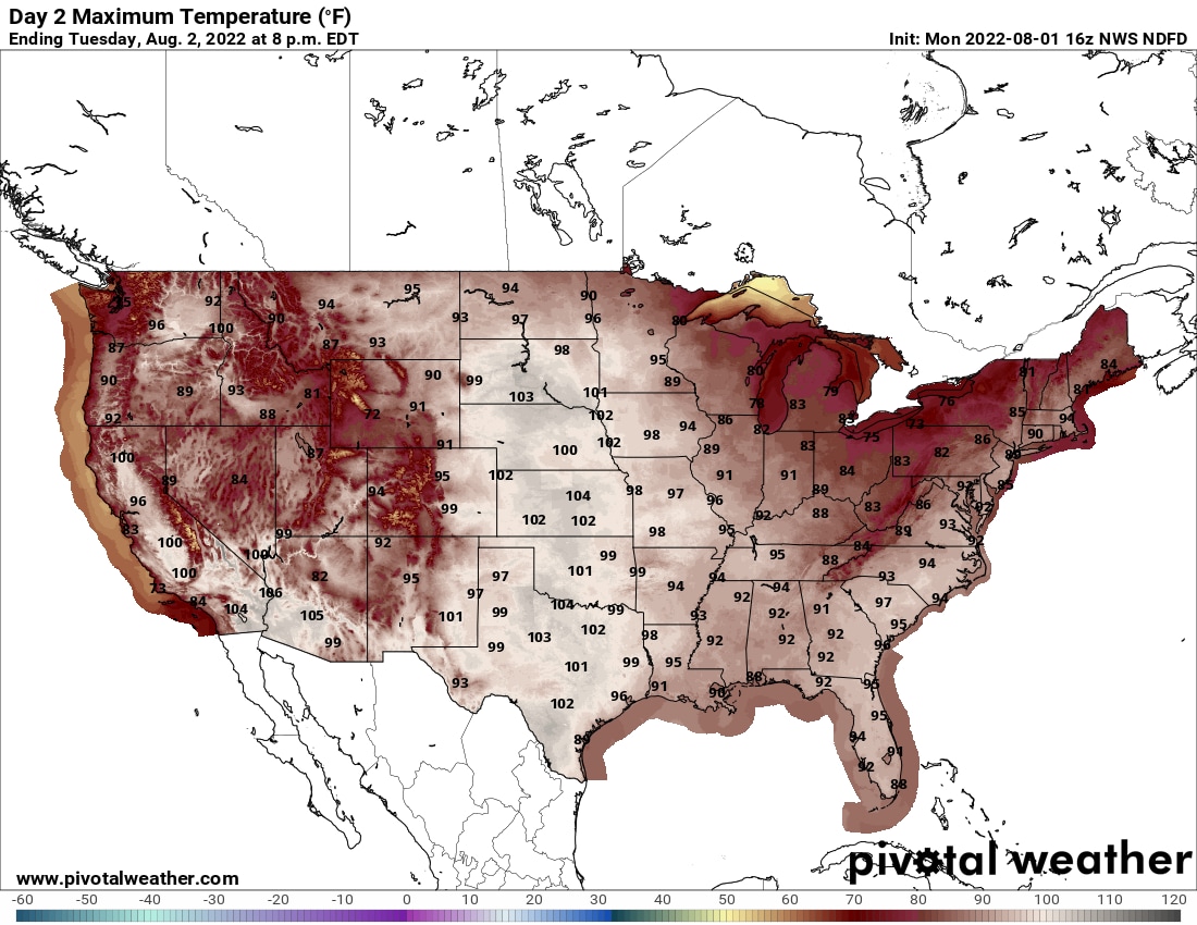
The core of the heat will settle over the central states Tuesday and Wednesday, and could extend into the Northeast on Thursday.
Here are the day-by-day hot spots:
- Numerous record highs between 90 and 105 degrees are forecast in the eastern Pacific Northwest and Northern Rockies from eastern Oregon to central Montana, including Billings, Helena, Great Falls and Missoula.
- Highs in the triple digits are forecast for much of the zone from Texas (away from the coast) to western Nebraska. While predicted highs are only in the mid-90s in Missouri, the heat indexes are forecast to reach 100 to 110, including in St. Louis.
- Highs of at least 100 degrees are anticipated from Texas (away from the coast) to South Dakota, with heat indexes up to 105 to 110.
- Highs in the 90s are projected to cover much of the South and Midwest, with a massive zone seeing heat indexes of 100 to 105, including Dallas, Oklahoma City, Wichita, Omaha, Des Moines, Kansas City, St. Louis and Little Rock. Heat indexes flirting with 100 could extend as far north as Minneapolis.
- The heat is concentrated from Texas through Illinois, with widespread forecast highs from the 90s to 105, and heat indexes from 100 to 110. The heat index could reach 100 as far north as Chicago and Detroit.
- The heat spreads into the Northeast. Boston and Hartford, Conn., are both expected to hit 96 degrees on Thursday, and Albany, NY, could spike to 98. That would tie a record set in 1955. Highs in the mid-90s are projected from DC to New York, with heat indexes 5 to 10 degrees higher.
- Most of the Southeast will be in the low to mid-90s, but oppressive humidity will push heat indexes into the upper 90s or even near 100.
- Across the Plains, upper 90s or lower 100s are likely. Dallas, Austin and San Antonio should see highs of 103 or 104 degrees.
Plains to keep baking in the longer range
A glance at the extended range, moreover, suggests that this heat dome could languish for a week or more, possibly into mid-August, as it consolidates over the Plains.
Here’s a look at how hot it could get:
- Upper 90s to lower 100s spread from Texas all the way north to the Canadian Border, peaking around 102 degrees in Rapid City, SD That would tie a record of set in 1964.
- Some cooler air sinks into the northern Plains, but highs well into the 90s and low 100s stretch from Texas to Iowa.