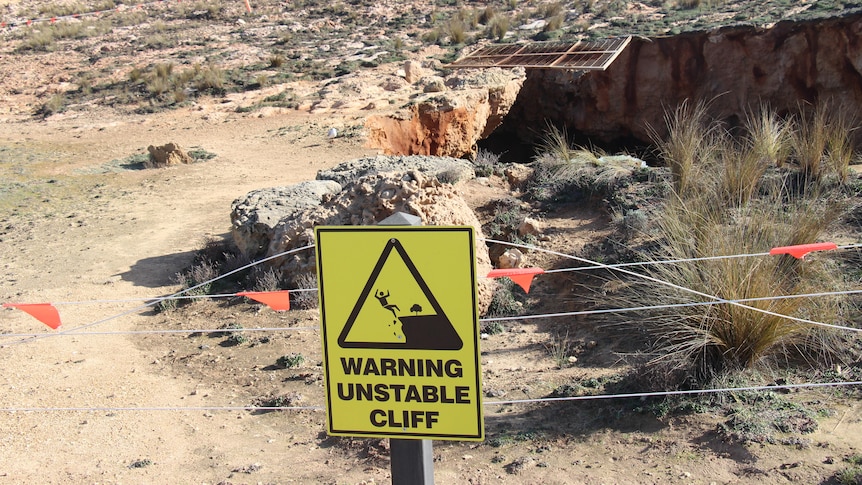
A coastal council in South Australia is warning the public to watch out for further cliff collapses around a giant hole that is growing near a popular tourist attraction.
Key points:
- Coastal cliffs around the Robe blowhole are continuing to collapse due to erosion and wave activity
- Locals have nicknamed a giant hole the ‘Woe Hole’ due to safety concerns
- A Flinders University professor says more erosion and subsequent collapses are likely
What used to be a small blowhole opening near the Robe obelisk has expanded into a significant gap after the surrounding cliff collapsed for a second time in recent months.
The hole was the size of half a tennis court when it suddenly appeared last year, and has widened since, with residents calling it the “Woe Hole” due to the concern it has caused.
District Council of Robe chief executive James Holyman said the collapses were “part of the natural cycle.”
“From time to time, we have pieces of the coastline fall,” he said.
But Mr Holyman said the “key thing” was that the public was safe.
“I want them to be very aware that we’ve roped off the Woe Hole,” he said.
“So that’s not a reason to jump the fence and go and have a look, because most people wouldn’t be aware where the key weak areas are.
“Don’t walk too close to the cliff face anywhere in Robe, because the worst outcome for us is that somebody is injured or killed because they’re not behaving in the right way.”
Mr Holyman said he had witnessed a person cross over the barrier and head towards the edge of the hole.
“Because I was there at the time, I was able to say to the individual, ‘Please, sir, come away from there, that area’s extremely unsafe’,” Mr Holyman said.
“But there’s not somebody there all the time.
“Individual decisions and individual behavior needs to be from a safety perspective.”
He said the limestone cliffs made it “very difficult” to erect more permanent safety barriers.
“We would struggle because it’s all limestone and it is porous in some areas, so putting posts and things in is very difficult,” Mr Holyman said.
“We are also reasonably certain — but we will continue to monitor — that it is going to continue to erode.
“So you could put a reasonable amount of infrastructure in but it would need to be replaced fairly quickly.”
The council has employed light detection and ranging (LiDAR) survey technology to determine the locations of weak spots in the cliffs.
“We’re very fortunate to have LiDAR, which has mapped the whole of the cave there,” Mr Holyman said.
“We know it’s getting reasonably close to the coastal trail, so we want to be proactive and plan where the trail goes in the future.”
More likely erosion
Flinders University strategic professor for coastal studies Patrick Hesp said these types of collapses were “likely” to continue.
“The continual erosion of the limestone along the Limestone Coast is occurring due to wave activity, and also solution by rainwater and groundwater,” he said.
“While there is a surface calcrete — which is this highly cemented, very lithified, very hard layer across the top of the limestone — it’s been very significantly excavated underneath into a cave by waves over time.”
Professor Hesp said continuous monitoring was key.
“We have, for example, [a] 2018 LiDAR flight along the coast and it’s critical to keep that kind of monitoring going,” he said.
“Unfortunately, it’s enormously expensive.
“It gives you incredible digital detail of the coast and so it’s a brilliant monitoring mechanism in terms of being able to see how the coast is changing.
“Certainly the rate of erosion that we see, for example, at Cape Dombey [in Robe] and other areas where we have some monitoring would indicate that, yes, the erosion is continuing everywhere.”
.
