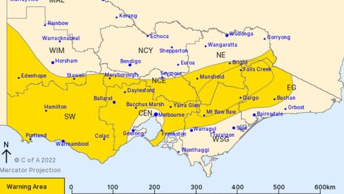
The Bureau of Meteorology (BOM) has warned winds could peak up to 100 km/h, reaching 110 km/h over elevated areas.
The strongest winds are expected this afternoon and will continue into Wednesday morning.

The bureau said a strong cold front will enter the west of the state late today, bringing a “vigorous north to north-westerly flow.”
Showers and thunderstorms are also likely for the affected areas.
A Watch and Act warning is now in place for resident’s to “prepare to take shelter” for the Central Highlands, Dandenong, Great Dividing Range.
A severe weather warning is in place for areas including Stawell, Hamilton, Warrnambool, Portland, Maryborough, Castlemaine, Kyneton, Ballarat, Frankston, Bacchus Marsh, Bright and Falls Creek.
Victorians urged to “prepare now”
The State Emergency Service has urged impacted residents to “prepare now” ahead of the wild conditions.
VICSES Chief Officer Operations Tim Wiebusch said it was important for residents to remain vigilant.
“Our volunteers across the state are prepared to assist communities with the severe weather conditions forecast for overnight tonight,” he said.
“However with damaging to destructive winds possible, it’s vital you remain vigilant and up to date on the latest warnings and advice.”
“Ensure you listen to the advice of emergency services, and secure loose items in and around your home, park your vehicle undercover, away from trees and remain indoors until the severe weather has passed.”

‘River City’ wakes to white-out as fog swallows city
Wiebusch said residents should ensure gutters, downpipes and drains are not blocked to cope with the potential of heavy rainfall.
There’s a high chance of showers in Melbourne tomorrow, and a possibility of a thunderstorm.
Temperatures are forecast to reach a top of 19C.
Call 132 500 for emergency assistance from VICSES.