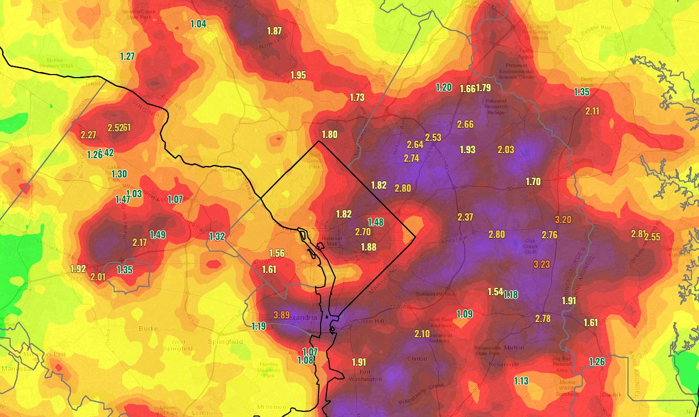
That hourly rainfall has a return interval of around 100 years according to National Weather Service data. In other words, that amount of rain has a 1 percent chance of happening in that area any given year. Another way to think about it is that such a 100-year rainstorm has a slightly greater than 1-in-4 chance of occurring within the term of a 30-year mortgage.
It’s not a coincidence that there were multiple reports of flooding in the zone where these extreme rainfall rates occurred.
Near Bladensburg, the Weather Service reported that the northeast branch of the Anacostia River rose more than 7.5 feet in an hour. Along Kenilworth Avenue at Riverdale Road, a number of lanes were blocked by high water.
Just to the east, closer to New Carrollton, the Weather Service reported multiple water rescues were required between Lanham and Glenn Dale.
Prince George’s County Fire/EMS Department tweeted Thursday that it responded to 71 water rescue calls during the storm. Eleven county school buildings were affected by minor flooding according to district spokeswoman Meghan Gebreselassie. Building services staff from the school district responded and cleared standing water from all the areas, she said.
As storms rolled through Prince George’s County yesterday, the men & women of the #PGFD completed 71 Water Rescue calls between the hours of 2 and 8pm. Several occupants of vehicles & 2 residents of a multi-family dwelling were assisted to safety by career & volunteer personnel. pic.twitter.com/TcKUXFrVwv
— Prince George’s County Fire/EMS Department (@PGFDNews) August 11, 2022
All told, the Weather Service received more than two dozen reports of flooding.
Prince George’s County was hardest hit, but substantial flooding also affected other areas. In Virginia, high water flooded roads between Vienna and Reston as well as in Alexandria — especially around Old Town.
Flooding was also reported in eastern portions of the District. Video went viral of water several feet high up against the door of District Dogs, a pet day-care center, along Rhode Island Avenue in Northeast Washington.
The owner of @dcdistrictdogs in NE says this is the 3rd time this new business has flooded in the last 3 weeks! Employees had to rush to move about 50 dogs to the back area after a few inches of water made it inside 1/2 pic.twitter.com/rK8Uh7bxch
— Lindsay Watts (@LindsayAWatts) August 10, 2022
The downpour in the DC area Wednesday joins several other notable rain events in the last two weeks. Even more extreme, thousand-year rainstorms occurred in St. Louis, eastern Kentucky, southern Illinois and Death Valley, Calif. There was also an exceptional and deadly flooding event this week in Seoul.
The torrents in the Washington region were set off by a slow-moving cold front as it clashed with a very hot, humid air mass. Precipitable water, an indicator of atmospheric moisture, was estimated up to 2.25 and 2.65 inches Wednesday evening between Alexandria and central Prince George’s County. Such levels are near records for the time of year.
Now that the front has passed, much cooler and drier air is settling into the DC region.
The most intense precipitation events around the world are increasing because of human-caused climate change. A warmer atmosphere is capable of holding more moisture and producing heavier rainfall.
The US government’s National Climate Assessment documented a 55 percent increase in the heaviest precipitation events in the Northeast between 1958 and 2016.
Nicole Asbury contributed to this report.
